Approximate Location Map
Large Map »
Latitude: 58.9843 / 58°59'3"N
Longitude: -2.9554 / 2°57'19"W
OS Eastings: 345185
OS Northings: 1011184
OS Grid: HY451111
Mapcode National: GBR M42Z.LVN
Mapcode Global: WH7C4.KFWY
Plus Code: 9CCVX2MV+PV
Entry Name: 26 St Catherine's Place, Kirkwall
Listing Name: 25 and 26 St Catherine's Place, Including Ancillary Building
Listing Date: 8 December 1971
Category: B
Source: Historic Scotland
Source ID: 381668
Historic Scotland Designation Reference: LB36801
Building Class: Cultural
ID on this website: 200381668
Location: Kirkwall
County: Orkney Islands
Town: Kirkwall
Electoral Ward: Kirkwall East
Traditional County: Orkney
Tagged with: House
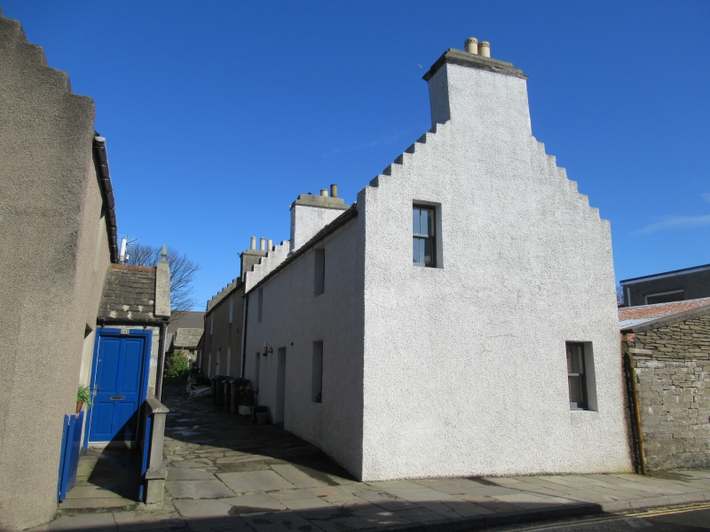
Circa 1805, with later alterations. 2-storey, pair of 3-bay rectangular-plan, crowstepped gabled houses with gabled (W) end to street, extending E, and single storey, lean-to addition to E gable. Harled.
N (PRINCIPAL) ELEVATIONS: NUMBER 25 (to W): deep-set part-glazed door at ground in bay to centre. Window at each floor in bays flanking. NUMBER 26: deep-set door at ground in bay to centre. Window at each floor in each bay flanking. Window in lean-to addition to outer left.
W (ST CATHERINE'S PLACE) ELEVATION: window at ground in bay to right; window at 1st floor in bay to left; gablehead above.
4-pane timber sash and case windows to Number 25; timber-framed windows with top-hung upper lights to Number 26. Traditional graded stone slated roofs; stone ridges; harled, corniced gablehead and ridge stacks; uPVC rainwater goods.
INTERIORS: not seen, 1998.
ANCILLARY BUILDINGS: small single storey, rubble lean-to shed sited to E; boarded doors; traditional graded stone slated roof.
B-Group with Numbers 9 to 12, 13 and 14, 15 to 18, 19 and 20, 21 and 22, 23 and 24 St Catherine's Plcace and 1 to 9 Cromwell Road. This pair of houses forms part of a small development on the eastern side of St Catherine's Place, constructed as workers' houses by a farmer, Andrew Drever, in the early part of the 19th century. Rows of houses (listed separately) stand in the traditional manner with their gabled ends to the street with flagstoned closes between. Collectively they form a surviving group of some quality. They retain their substantial harled stacks and crowstepped gables. The small ancillary building sited to the E forms part of a continuous row of similar sheds, each allocated to houses further along the development.
External links are from the relevant listing authority and, where applicable, Wikidata. Wikidata IDs may be related buildings as well as this specific building. If you want to add or update a link, you will need to do so by editing the Wikidata entry.


Other nearby listed buildings
