Approximate Location Map
Large Map »
Latitude: 56.4121 / 56°24'43"N
Longitude: -5.4729 / 5°28'22"W
OS Eastings: 185855
OS Northings: 729842
OS Grid: NM858298
Mapcode National: GBR DCVR.ZX3
Mapcode Global: WH0GK.X307
Plus Code: 9C8PCG6G+RR
Entry Name: Former Clydesdale Bank, Argyll Square, Oban
Listing Name: Argyll Square, Former Clydesdale Bank
Listing Date: 16 May 1995
Category: C
Source: Historic Scotland
Source ID: 384281
Historic Scotland Designation Reference: LB38812
Building Class: Cultural
ID on this website: 200384281
Location: Oban
County: Argyll and Bute
Town: Oban
Electoral Ward: Oban South and the Isles
Traditional County: Argyllshire
Tagged with: Bank building
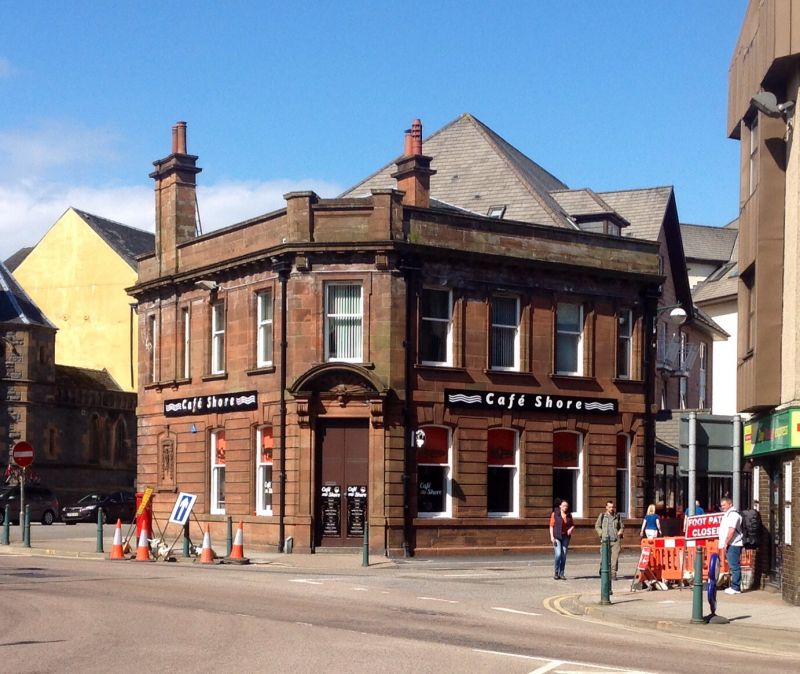
Baird and Thomson of Glasgow, 1915, with alterations, 1936. 2-storey classical bank building of irregular plan with 3 principal facades to Shore Street, Argyll Square, and Station Road. Angled rear (W) elevation. Red sandstone ashlar, horizontally channelled at ground floor, squared and snecked grey granite rubble, rear elevation blank. Chamfered E corner with main entrance door. Base course, band course at ground floor cill and 1st floor. String course at 1st floor cill, bracketted cornice with parapet above. Ground floor windows with channelled voussoirs and keystone at centres. Architraved and shouldered 1st floor windows with corniced cills.
SHORE STREET (S) ELEVATION: 3 bays with architraved doorway in bay 1.
ARGYLL SQUARE (SE) ELEVATION: 3 bays, architraved, arched and shouldered armorial panel with keystone and carved crest at ground floor bay 1. Bracketted pilaster strips extending from 1st floor cill level to wallhead stack above, flanked by narrow windows. Chamfered corner to right, 1 bay wide, pilastered entrance doorway with scrolled brackets at top supporting open segmental pediment with cartouche and shell motif.
STATION ROAD (NE) ELEVATION: 4 bays with narrower window openings in bay 4. Plate glass timber sash and case windows, altered lower sashes
at ground floor. Grey-slated piended roof, square cast-iron downpipes with shallow hoppers at corners. 3-flue ashlar wallhead stack at SE elevation bay 1, 2-flue ashlar wallhead stacks at N and S corners of rear elevation, all with double-corniced copes.
Although this building has been left stranded by other demolitions, it continues to enclose the W end of Argyll Square. Cast-iron pillar box adjacent to SE elevation.
External links are from the relevant listing authority and, where applicable, Wikidata. Wikidata IDs may be related buildings as well as this specific building. If you want to add or update a link, you will need to do so by editing the Wikidata entry.


Other nearby listed buildings
