Approximate Location Map
Large Map »
Latitude: 55.8262 / 55°49'34"N
Longitude: -3.2221 / 3°13'19"W
OS Eastings: 323535
OS Northings: 659890
OS Grid: NT235598
Mapcode National: GBR 51Y2.69
Mapcode Global: WH6T5.GTWG
Plus Code: 9C7RRQGH+F5
Entry Name: The Old Well, High Street, Penicuik
Listing Name: High Street, Old Well (Cowan Well)
Listing Date: 4 February 1993
Category: B
Source: Historic Scotland
Source ID: 384928
Historic Scotland Designation Reference: LB39299
Building Class: Cultural
ID on this website: 200384928
Location: Penicuik
County: Midlothian
Town: Penicuik
Electoral Ward: Penicuik
Traditional County: Midlothian
Tagged with: Architectural structure
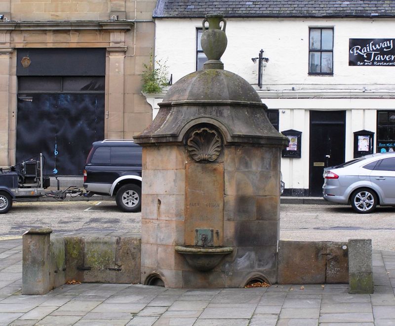
J A Bell, erected 1864. Polished ashlar sandstone octagonal well head, with ogee cap and amphora finial; flanked by curved dwarf walls with coped terminals, terminal to NE with cope missing, terminal to SW surmounted by decorative cast-iron lamp standard.
WELL: slightly advanced tooled stone panel centred in street face of octagonal base, inscribed 'The Gift of Alexr. Cowan. 1864' incorporating square metal panel and metal well tap, with advanced basin with roll-moulded coped rim centred below. Flanking sides with part-infilled arched recesses at ground for watering dogs. Ogee cap extended to form cornice, arched over street face of octagon, with scallop shell centred in arch head. Cast-iron plaque to rear face, inset with inscription recording construction of the well and its predecessor, reading, 'The old well was built on this site in 1809 by D and A Cowan who also put up the public cart weights near this at the same time. This new well designed by J A Bell architect was erected in 1864 for the water of the old spring and for the water from Sillerburn... ...at the expense and by the desire of the late Alexander Cowan'.
Replacing a wellhead of 1809, the old well was superseded by piped water from Sillerburn. Also known as Cowan Well, as it was built at the expense of the late papermaker Alexander Cowan of Valleyfield. The well sits to the SW of the terrace on which the north side of the High Street is built upon.
External links are from the relevant listing authority and, where applicable, Wikidata. Wikidata IDs may be related buildings as well as this specific building. If you want to add or update a link, you will need to do so by editing the Wikidata entry.


Other nearby listed buildings
