Approximate Location Map
Large Map »
Latitude: 55.4907 / 55°29'26"N
Longitude: -4.6233 / 4°37'24"W
OS Eastings: 234356
OS Northings: 625001
OS Grid: NS343250
Mapcode National: GBR 3B.W01X
Mapcode Global: WH2PP.Y8L4
Plus Code: 9C7QF9RG+7M
Entry Name: Salt Pan Houses, St Nicholas Golf Course, Prestwick
Listing Name: Salt Pan Houses at St Nicholas Golf Course
Listing Date: 20 January 1989
Category: A
Source: Historic Scotland
Source ID: 386250
Historic Scotland Designation Reference: LB40332
Building Class: Cultural
ID on this website: 200386250
Location: Prestwick
County: South Ayrshire
Town: Prestwick
Electoral Ward: Prestwick
Traditional County: Ayrshire
Tagged with: Architectural structure
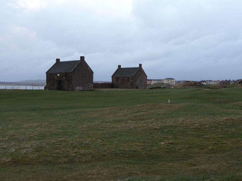
Built circa 1760 for the salt boiling industry, as the
Maryburgh Salt Works, probably salt pans with housing above.
Pair parellel blocks linked by (? later) wall which has
been heightened and which was originally open at centre.
Arrangement is broadly symmetrical. Blocks are 2-storey, rectangular-plan, gabled, with end stacks, rubble-built
with squared dressings (south block part harled), each block
with wide opening in west gable at low level (timber-lintelled
at south, concrete at north); also forestairs; slate roofs;
deep skews with moulded skewputts suggest roof covering may
originally have been pantiles or thatch.
Although what remains is incomplete, Whatley describes
surviving buildings as "certainly the most complete
upstanding remains of the (saltboiling) industry on the west
coast". In fact, they appear to be most complete to survive
in Scotland.
The Prestwick burgh/records of 12th February 1480 uses the
term "salt pan hous" which suggests the existence of
the industry locally by that time. The burgh records also
discussed applications for erecting of salt pans on 25th
June 1763 and 7th Sept. 1765 (Information provided by
Kyle & Carrick civic society).
External links are from the relevant listing authority and, where applicable, Wikidata. Wikidata IDs may be related buildings as well as this specific building. If you want to add or update a link, you will need to do so by editing the Wikidata entry.


Other nearby listed buildings
