Approximate Location Map
Large Map »
Latitude: 56.3394 / 56°20'21"N
Longitude: -2.7923 / 2°47'32"W
OS Eastings: 351115
OS Northings: 716618
OS Grid: NO511166
Mapcode National: GBR 2R.4GMM
Mapcode Global: WH7S0.2XLJ
Plus Code: 9C8V86Q5+Q3
Entry Name: 46 South Street, St Andrews
Listing Name: 46 South Street, with Garden Walls of Lang Rig.
Listing Date: 28 April 1959
Category: B
Source: Historic Scotland
Source ID: 386639
Historic Scotland Designation Reference: LB40678
Building Class: Cultural
ID on this website: 200386639
Location: St Andrews
County: Fife
Town: St Andrews
Electoral Ward: St Andrews
Traditional County: Fife
Tagged with: House
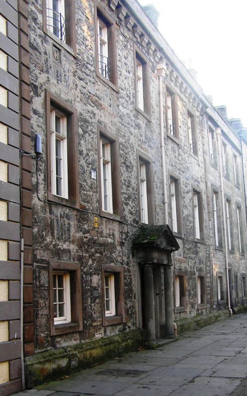
1723 incorporating 16th and 17th cent. work. Front 3-storey,
5-window rubble-built with v-jointed pilaster strips at ends,
Roman doric column pedimented doorpiece with Hadow arms;
panel with arms of Balfour of Montquhanie; slated and crowstepped.
The lang rig garden walls of nos. 44-62 are partly mediaeval
and correspond to the disposition of 1567.
Extended to W in 1880 (see separate listing for 48 South Street).
External links are from the relevant listing authority and, where applicable, Wikidata. Wikidata IDs may be related buildings as well as this specific building. If you want to add or update a link, you will need to do so by editing the Wikidata entry.


Other nearby listed buildings
