Approximate Location Map
Large Map »
Latitude: 56.3393 / 56°20'21"N
Longitude: -2.7932 / 2°47'35"W
OS Eastings: 351064
OS Northings: 716612
OS Grid: NO510166
Mapcode National: GBR 2R.4GG5
Mapcode Global: WH7S0.2X6K
Plus Code: 9C8V86Q4+PP
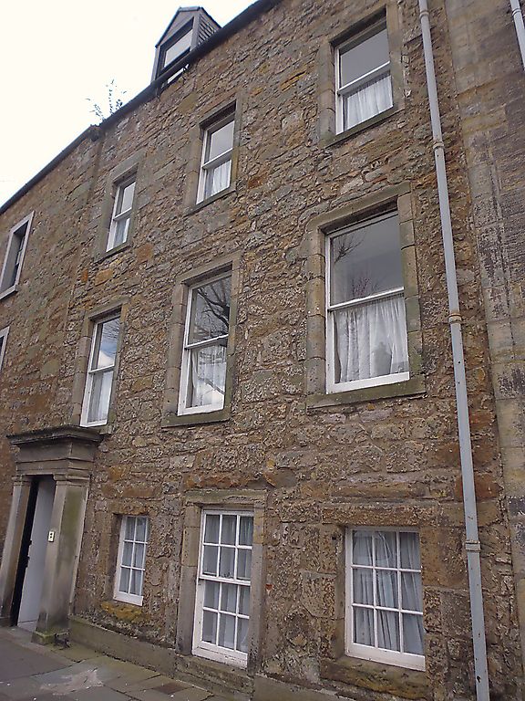
Entry Name: 60 South Street, St Andrews
Listing Name: 60 South Street, with Garden Walls of Lang Rig.
Listing Date: 28 April 1959
Category: B
Source: Historic Scotland
Source ID: 386645
Historic Scotland Designation Reference: LB40684
Building Class: Cultural
ID on this website: 200386645
Location: St Andrews
County: Fife
Town: St Andrews
Electoral Ward: St Andrews
Traditional County: Fife
Tagged with: Architectural structure
Early 17th cent. 3-storey and attic, 3-window; rubble with
diamford margins; anta doorpiece of c. 1820; 2 gabled
dormers; slated. Crowstepped wing at back c. 1620 cleared of
later additions 1970. Scale-and-platt stair. Lang rig
shortened at S end, bee-boles and armorial stone.
External links are from the relevant listing authority and, where applicable, Wikidata. Wikidata IDs may be related buildings as well as this specific building. If you want to add or update a link, you will need to do so by editing the Wikidata entry.


Other nearby listed buildings
