Approximate Location Map
Large Map »
Latitude: 58.2094 / 58°12'33"N
Longitude: -6.3813 / 6°22'52"W
OS Eastings: 142742
OS Northings: 932881
OS Grid: NB427328
Mapcode National: GBR B7M0.XJQ
Mapcode Global: WGY2Y.YXGH
Plus Code: 9CCM6J59+QF
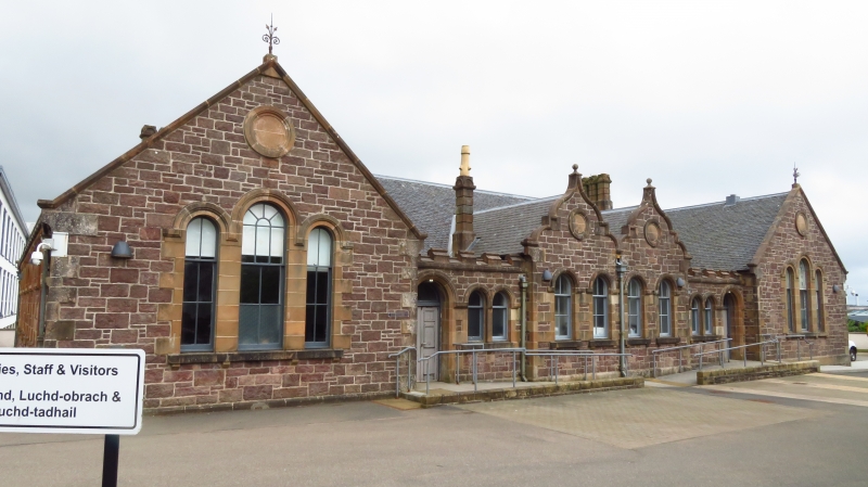
Entry Name: School Block, Matheson Road And Springfield Road, Stornoway, Lewis
Listing Name: Matheson Road and Springfield Road, School Block
Listing Date: 13 July 1990
Category: B
Source: Historic Scotland
Source ID: 388057
Historic Scotland Designation Reference: LB41715
Building Class: Cultural
ID on this website: 200388057
Location: Stornoway
County: Na h-Eileanan Siar
Town: Stornoway
Electoral Ward: Steòrnabhagh a Deas
Traditional County: Ross-shire
Tagged with: School building
Late 19th century in appearance. Single storey school block with long symmetrical front to Matheson Road, round-arched openings throughout; contrasting rock-faced and polished yellow ashlar, slate roofs; twin-gabled centre, wider outer gables. Original glazing pattern throughout, and decorative stone chimney flues.
External links are from the relevant listing authority and, where applicable, Wikidata. Wikidata IDs may be related buildings as well as this specific building. If you want to add or update a link, you will need to do so by editing the Wikidata entry.


Other nearby listed buildings
