Approximate Location Map
Large Map »
Latitude: 58.4383 / 58°26'18"N
Longitude: -3.0856 / 3°5'8"W
OS Eastings: 336717
OS Northings: 950514
OS Grid: ND367505
Mapcode National: GBR L6RF.785
Mapcode Global: WH6DN.K5WF
Plus Code: 9CCRCWQ7+8Q
Entry Name: 1 Breadalbane Crescent, Wick
Listing Name: 1 Breadalbane Crescent Including Rear Garden Wall
Listing Date: 14 September 1983
Category: B
Source: Historic Scotland
Source ID: 388785
Historic Scotland Designation Reference: LB42287
Building Class: Cultural
ID on this website: 200388785
Location: Wick
County: Highland
Town: Wick
Electoral Ward: Wick and East Caithness
Traditional County: Caithness
Tagged with: House
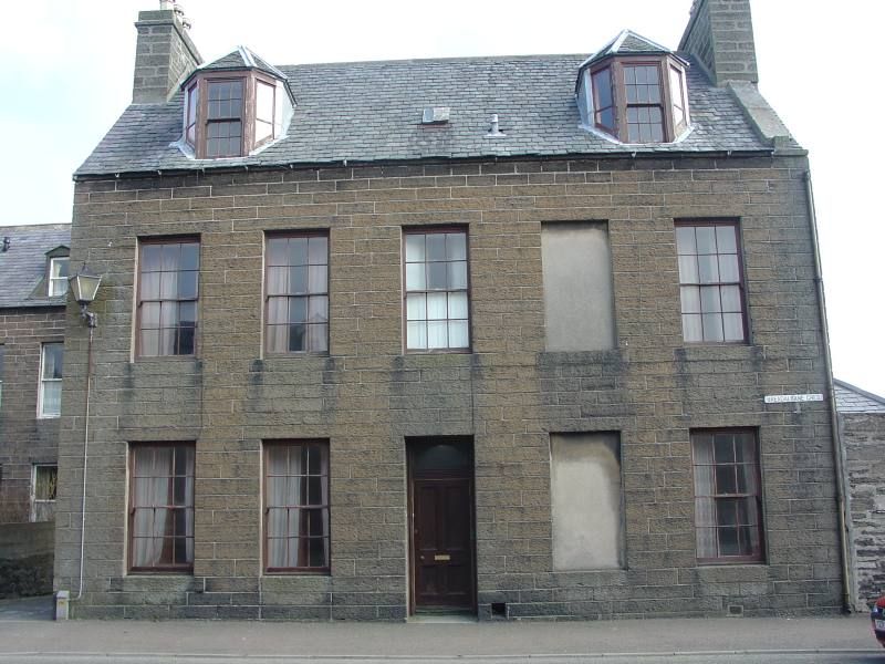
Circa 1860. 2-storey with attic, 5-bay, symmetrical, rectangular-plan, gabled house. Coursed Caithness stone slabs.
SW (PRINCIPAL) ELEVATION: panelled door to centre, regular fenestration, blind windows to 4th bay; canted dormers.
NE (REAR) ELEVATION: not seen 2001.
NW (SIDE) ELEVATION: blind doorway to ground floor right, window to upper storey left.
SE (SIDE) ELEVATION: single storey, advanced bay with piended roof. Window to upper storey right, square attic window above.
INTERIOR: not seen 2001.
Modern sash and case windows. Grey slates, lead flashing. Coped skews and gable stacks. Cast-iron rainwater goods.
The A-Group for Upper Pulteneytown comprises: 1,2; 4,5,6; 11,12,13,14,15,17,18; 20,22; 30,31,33; 35-41,43,44,45,46,48,49; 51-55,57-59; 62,63 Argyle Square; 65 Argyle Square and 1 Grant Street; Pulteneytown Parish Church, Argyle Square; 1; 4,6; 8,9; 10,11,12,13; 14,15,16,17,18 Breadalbane Crescent; 1,2,3; 5,6; 12,13; 15; 17,18,19; 22,23,24,25; 26,27; 28,29; 31; 32; 37,38; 41; 42; 46; 47; 48,49 Breadalbane Terrace; 3,5; 8,10 Dempster Street; Wick Central Church of Scotland, Dempster Street; 7,9; 11 Malcolm Street; 1,2; 3,4,5,6; 7,8,9,10; 13; 15,16; 17; 18; 20 Sinclair Terrace. The Group listing is in recognition of the exceptional group value of these buildings as the core of Thomas Telford's 1809 scheme for the new town plan of Pulteneytown for the British Fisheries Society. The eastern part of Breadalbane Crescent consists of large town houses of greater size and quality than the rest of Pulteneytown. The presence of railed front gardens are unique to this row as are the rear paved yards and outbuildings. Originally built and occupied by the magnates of the Pulteneytown herring boom the outhouses consisted of cooperages and bothy accommodation for itinerant fish workers, usually women gutters. For further information see separate listing for 1,2 Argyle Square.
External links are from the relevant listing authority and, where applicable, Wikidata. Wikidata IDs may be related buildings as well as this specific building. If you want to add or update a link, you will need to do so by editing the Wikidata entry.


Other nearby listed buildings
