Approximate Location Map
Large Map »
Latitude: 55.5482 / 55°32'53"N
Longitude: -2.8426 / 2°50'33"W
OS Eastings: 346935
OS Northings: 628598
OS Grid: NT469285
Mapcode National: GBR 84L8.DY
Mapcode Global: WH7WV.9TM1
Plus Code: 9C7VG5X4+7X
Entry Name: 12 Ettrick Terrace, Selkirk
Listing Name: 12 Ettrick Terrace
Listing Date: 11 December 1996
Category: C
Source: Historic Scotland
Source ID: 390354
Historic Scotland Designation Reference: LB43751
Building Class: Cultural
ID on this website: 200390354
Location: Selkirk
County: Scottish Borders
Town: Selkirk
Electoral Ward: Selkirkshire
Traditional County: Selkirkshire
Tagged with: Architectural structure
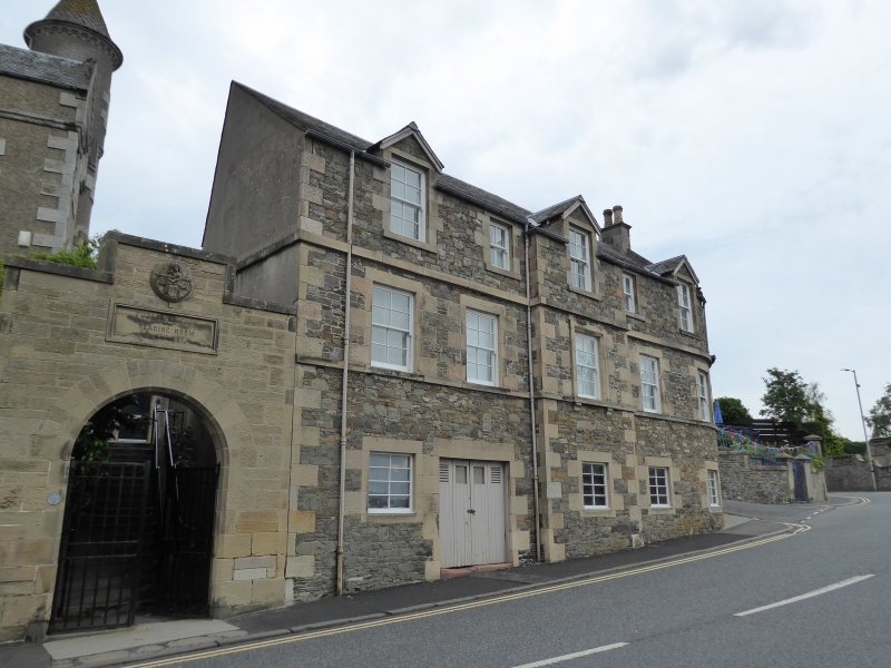
Later 19th century with later alterations. 3-storey, 5-bay building, sited on ground rising to SE. Whinstone rubble at ground with roughly squared and snecked whinstone to upper storeys with droved sandstone ashlar dressings; harled NE and SW elevations with droved ashlar dressings. Cill course to 1st floor; band course between 1st and 2nd floors; flush droved ashlar long and short quoins; droved ashlar tails to openings.
NW (ETTRICK TERRACE) ELEVATION: small window openings at ground and to 2nd floor of inner bays. Advanced bay to centre with window to each storey, breaking eaves with gabled dormerhead at 2nd floor. 4-leaf boarded door at ground of inner bay to left with glazed (inner leaves) and louvred (outer leaves) panels at head; window to each floor above. Window to each floor of outer bays, breaking eaves as at centre. Bay to inner right same as that to inner left, except window at ground. Wall swept at ground and 1st floor to outer right to SW elevation.
SW ELEVATION: platformed bow at ground and 1st floor with window at 1st floor. Gabled at 2nd floor above.
SE ELEVATION: 2-storey, 4-bay group with band course between storeys. Window at ground and 1st floor of bay to inner right. Louvred opening at ground, window at 1st floor above in bay to inner left. Boarded door in bay to outer left with 3-pane rectangular fanlight, flanked to left by narrow window; window at 1st floor, breaking eaves with gabled dormerhead. Similar door and fanlight in bay to outer right, flanked by narrow windows; window at 1st floor, breaking eaves with gabled dormerhead.
8-pane and 4-pane timber sash and case windows; some alterations to glazing at ground of NW elevation. Slate roof. Plain bargeboarding to dormerheads. Ashlar coped skews. Ashlar coped wallhead stack to SW; shouldered angled coped ashlar stack to outer left of SW, from platform at 1st floor; harled later wallhead stack to SE to right of bay to outer right.
INTERIOR: not seen, 1996.
The building first appears on 2nd edition OS map (1865) and was a police station at that time.
External links are from the relevant listing authority and, where applicable, Wikidata. Wikidata IDs may be related buildings as well as this specific building. If you want to add or update a link, you will need to do so by editing the Wikidata entry.


Other nearby listed buildings
