Approximate Location Map
Large Map »
Latitude: 55.5477 / 55°32'51"N
Longitude: -2.8406 / 2°50'26"W
OS Eastings: 347061
OS Northings: 628538
OS Grid: NT470285
Mapcode National: GBR 84L9.T4
Mapcode Global: WH7WV.BTLG
Plus Code: 9C7VG5X5+3Q
Entry Name: 16, 18 High Street, Selkirk
Listing Name: 16 and 18 High Street
Listing Date: 11 December 1996
Category: C
Source: Historic Scotland
Source ID: 390392
Historic Scotland Designation Reference: LB43779
Building Class: Cultural
ID on this website: 200390392
Location: Selkirk
County: Scottish Borders
Town: Selkirk
Electoral Ward: Selkirkshire
Traditional County: Selkirkshire
Tagged with: Tenement
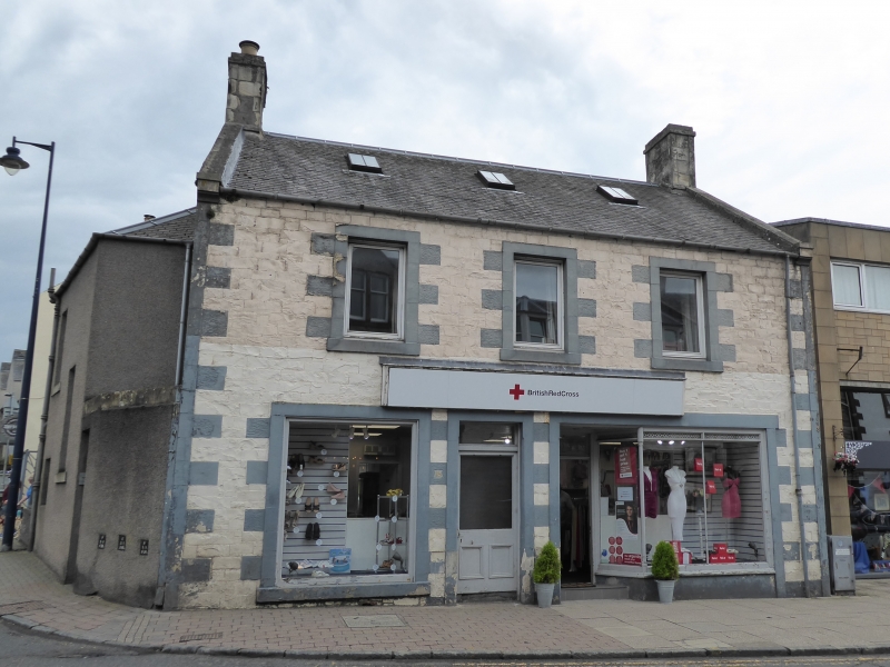
Earlier 19th century with later additions and alterations. 2-storey, 3-bay tenement with shop at ground. Squared and snecked whinstone with polished ashlar margins, droved ashlar tails to windows at 1st floor; whinstone rubble at ground with harling at 1st floor to SE and SW elevations; harled NE elevation with ashlar cills. Quoin strips with flush long and short droved ashlar quoins; stop-chamfered arrises to door openings at ground.
NW (HIGH STREET) ELEVATION: deep-set partly-glazed shop door to right of centre; partly-glazed door with plate glass rectangular fanlight above to left of centre. Each flanked by large plate glass windows (set in later 19th century shop front in bay to right). Window to each bay at 1st floor. Evidence of former uniting, corniced shop fascia.
SE ELEVATION: full-height projection from bay to left. Further projection to NE.
Variety of windows, modern plate glass swinging windows to NW at 1st floor with plate glass fixed-pane windows at ground; plate glass and 12-pane timber sash and case windows. Slate roof with ashlar coped skews and skewputts. Ashlar coped wallhead stacks to side elevations.
INTERIOR: not seen, 1996.
The building is on a prominent site, on the corner of Tower Street and High Street. There is a building shown on this site in 1823 and the plan of the building shown on 2nd edition OS map (1865) is the same as the one seen now. Turner Simpson and Stevenson say that this is "probably the site of one of the earliest substantial town buildings known". A sasine document dating from 1621 indicates the presence of a tower house on the site (ibid, p16). This seems to have survived up to early 18th century.
External links are from the relevant listing authority and, where applicable, Wikidata. Wikidata IDs may be related buildings as well as this specific building. If you want to add or update a link, you will need to do so by editing the Wikidata entry.


Other nearby listed buildings
