Approximate Location Map
Large Map »
Latitude: 55.9375 / 55°56'14"N
Longitude: -3.1725 / 3°10'20"W
OS Eastings: 326854
OS Northings: 672223
OS Grid: NT268722
Mapcode National: GBR 8SM.W2
Mapcode Global: WH6ST.71K2
Plus Code: 9C7RWRPH+X2
Entry Name: 1 Blacket Place, Edinburgh
Listing Name: 1 Blacket Place, Including Former Carriage House and Boundary Walls
Listing Date: 25 March 1997
Category: B
Source: Historic Scotland
Source ID: 390884
Historic Scotland Designation Reference: LB44199
Building Class: Cultural
ID on this website: 200390884
Location: Edinburgh
County: Edinburgh
Town: Edinburgh
Electoral Ward: Southside/Newington
Traditional County: Midlothian
Tagged with: Architectural structure
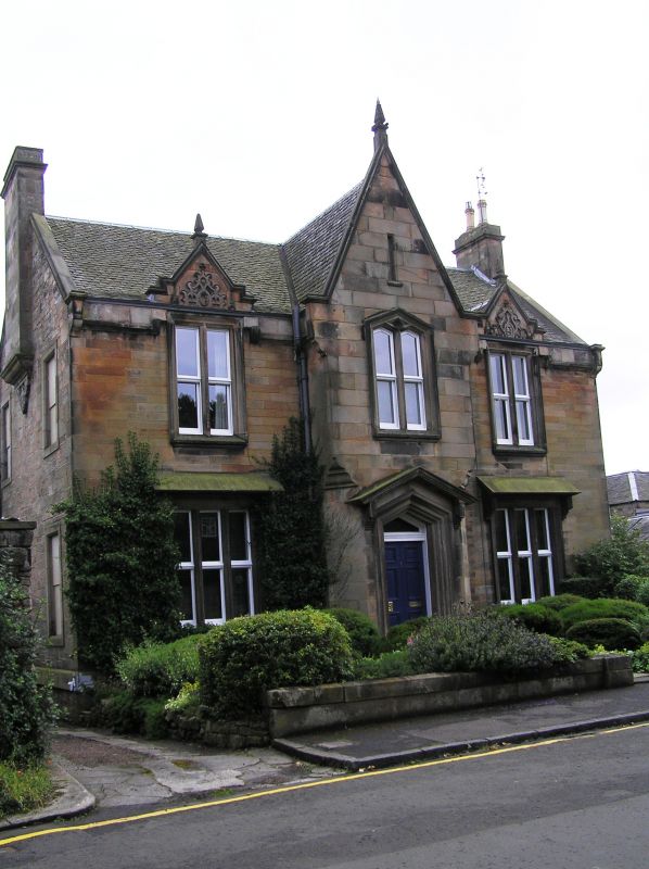
Later 19th century, before 1867. 2-storey, symmetrical 3-bay Jacobean style house. Stugged sandstone ashlar with polished dressings. Base course; stone mullions and timber transoms to architraved windows; eaves band course.
N (ENTRANCE) ELEVATION: advanced gabled central bay, chamfered at ground floor, corbelled to square at 1st floor; lancet-headed, architraved and roll moulded doorway with stone bracketed canopy; timber panelled door; lancet-headed bipartite window 1st floor above; blinded arrow slit set in gablehead; block skewputts; obelisk finial. Stone canopies to tripartite windows at ground in outer bays; bipartite windows at 1st floor above breaking eaves in pedimented dormerheads with decorative strapwork; obelisk finials.
E (SIDE) ELEVATION: single windows at ground and 1st floor to outer left and right; corbel with decorative strapwork supports corniced gablehead stack.
W (SIDE) ELEVATION: corbel with decorative strapwork supports corniced gablehead stack.
2-pane timber sash and case windows. Grey slate roof, swept at eaves; block skewputts; cast-iron rainwater goods.
INTERIOR: not seen 1996.
FORMER CARRIAGE HOUSE: tall narrow gable carriage house to SE; boarded 2-leaf door at ground; single window above; gable detailed as central gable of main building.
BOUNDARY WALLS: low boundary wall to street (railings missing), coped mutual boundary wall to W and high coped rubble mutual boundary wall to E.
Dr Benjamin Bell of Hunthill, an eminent Edinburgh surgeon and farmer, speculated on the potential for development in the lands of Newington. In 1806, aware of the demand for countrified dwellings near the city, he advertised his intention to sell 58 plots of land within his 8.5 acres. On his death in the same year his son George Bell, also a surgeon, inherited the land and, in 1825, commissioned James Gillespie Graham to design a plan for new streets within the grounds of Newington House, bounded by the back garden walls of Minto Street, Salisbury Road, East Mayfield and Dalkeith Road. Feus were offered for sale and Blacket Place began to take shape, the houses possibly being built speculatively by one builder or building company. Security was an important feature of the development, with Gothic gates, the octagonal piers of which survive, locked at night and single storey lodges at the entrances from Minto Street and Dalkeith Road.
External links are from the relevant listing authority and, where applicable, Wikidata. Wikidata IDs may be related buildings as well as this specific building. If you want to add or update a link, you will need to do so by editing the Wikidata entry.


Other nearby listed buildings
