Approximate Location Map
Large Map »
Latitude: 58.9576 / 58°57'27"N
Longitude: -3.301 / 3°18'3"W
OS Eastings: 325260
OS Northings: 1008548
OS Grid: HY252085
Mapcode National: GBR L561.YBK
Mapcode Global: WH6B1.83BW
Plus Code: 9CCRXM5X+2H
Entry Name: 2 South End, Stromness
Listing Name: 2 South End, Including Quay
Listing Date: 24 March 1998
Category: C
Source: Historic Scotland
Source ID: 392303
Historic Scotland Designation Reference: LB45420
Building Class: Cultural
ID on this website: 200392303
Location: Stromness
County: Orkney Islands
Town: Stromness
Electoral Ward: Stromness and South Isles
Traditional County: Orkney
Tagged with: House
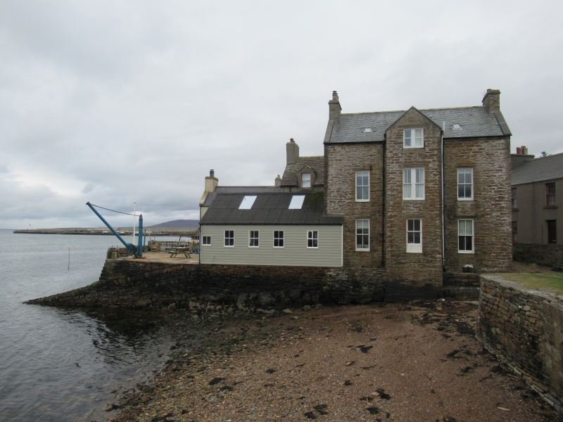
Late 18th century with later alterations and additions. 2-storey and attic, 3-bay rectangular-plan symmetrical house with 4-bay pitch-roofed timber former boat-building shed projection to E. Re-pointed roughly coursed and squared rubble.
S (PRINCIPAL) ELEVATION: timber panelled door with fanlight at ground in bay to centre; window at 1st floor above. Window at each floor in bays flanking. Window in each bay to boat shed to outer right.
N (REAR) ELEVATION: full-height gabled bay to centre; window at each floor. Windows at ground and 1st floors in each bay flanking. Window in each bay to boat shed to outer left.
W (SIDE) ELEVATION: single bay gabled elevation. Window at each floor to left; gablehead stack above.
E (SIDE) ELEVATION: sliding door to centre; 3 lights (tall light to centre) to gablehead; window, set to right at 1st floor and attic; gablehead stack above.
4-pane timber sash and case windows; fixed 4-pane timber-framed windows to boat shed. Grey slate roof; stone ridge; slate to dormer; corrugated perspex to boat shed; replaced cconcrete skews; corniced rubble gablehead stacks to E and W; uPVC rainwater goods.
INTERIOR: not seen, 1997.
QUAY: Caithness flagstones to rectangular-plan quay to E with low coped rubble wall to E border; concrete slight to transverse laid rubble slipway to SE angle; operational cast-iron boat derrick to SE angle.
External links are from the relevant listing authority and, where applicable, Wikidata. Wikidata IDs may be related buildings as well as this specific building. If you want to add or update a link, you will need to do so by editing the Wikidata entry.


Other nearby listed buildings
