Approximate Location Map
Large Map »
Latitude: 55.9805 / 55°58'49"N
Longitude: -3.223 / 3°13'22"W
OS Eastings: 323781
OS Northings: 677071
OS Grid: NT237770
Mapcode National: GBR 8G3.MM
Mapcode Global: WH6SD.GYG3
Plus Code: 9C7RXQJG+6Q
Entry Name: 159 Lower Granton Road And Gatepiers, Edinburgh
Listing Name: 159 Lower Granton Road, Former Stables, Including Gatepiers and Boundary Wall
Listing Date: 28 November 1989
Category: B
Source: Historic Scotland
Source ID: 392616
Historic Scotland Designation Reference: LB45656
Building Class: Cultural
ID on this website: 200392616
Location: Edinburgh
County: Edinburgh
Town: Edinburgh
Electoral Ward: Forth
Traditional County: Midlothian
Tagged with: Architectural structure
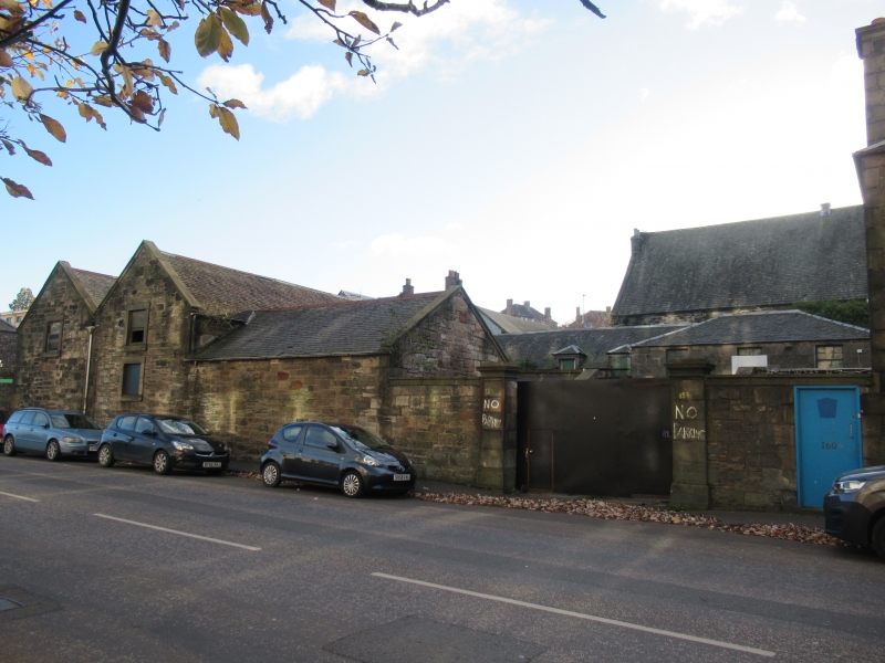
Circa 1840. Single and 2-storey with plain classical detailing. Stable complex grouped around central courtyard; 7 bays of carriage housing with accommodation above to S; range of stables with haylofts to E; and single storey stable/storage section to N. Coursed, tooled sandstone with droved ashlar dressings. Ashlar coped gables.
N (LOWER GRANTON ROAD) ELEVATION: pair of ashlar gatepiers with moulded coping; short section of retaining wall with ashlar coping to left; single storey section (blank) to left of this; 2-storey coped gable end to far left (with single architraved window to each floor). Flanking quoins to this bay delineate end of stable complex (adjoining building forming valley roof to left belongs to separate and later construction).
COURTYARD ELEVATIONS: 2-storey carriage house to S side: symmetrical central block of 3 bays with segmental-headed carriage arch to each and window above; 2 similar bays set back to either side; those to right have piended dormer windows; upper storey of those to left obscured by corrugated iron roof; carriage entrance to 6th bay infilled with brick and door and window inserted; flanking outer entrances to elevation. 2-storey stable section to E side: 6 bays (grouped 2-2-2) with alternate dormer windows to hayloft; entrances to 1st and 5th bays. N elevation; single storey stables/storage section; 2-bay section to right; entrance to left; curved corner with quoins to left; single window to left return; wall slopes down to meet gatepier. Short single storey section with lean-to roof to W side; single window to left; rendered flat-roofed extension to right. Adjoins rear wings of The Granton Tap, Lower Granton Road and The Anchorage, 7 Granton Road on this side.
Mainly 12-pane timber sash and case windows. Grey slate roofs: piended to central carriage housing section; 4 corniced ashlar stacks to W side, probably shared with adjoining properties; Much of E part of courtyard is roofed over with corrugated iron (1997). Cast-iron rainwater goods.
INTERIOR: much of original layout intact: including several wooden horse stalls with cast-iron posts to N and E ranges; original or early fireplace with stone surround and intact cast iron range to main room in W range. Rooms interconnect with adjoining properties.
BOUNDARY WALL: curved section of coursed rubble wall (a later addition) separates property from adjacent pub; this adjoins original coped section of coursed sandstone before western gatepier where it rises and curves to meet pub.
One of a number of buildings erected by the Duke of Buccleuch at the entrance to his newly-constructed harbour in the late 1830?s and 1840?s. Built to house the carriages and horses of visitors to the adjacent hotel on Granton Square (and the adjoining 'Granton Tap', originally the hotel's tap room). It would also appear to have been directly connected to 7 Granton Road (the ground floor of the stables being at the level of the basement of this house), which may have housed the stablemaster.
External links are from the relevant listing authority and, where applicable, Wikidata. Wikidata IDs may be related buildings as well as this specific building. If you want to add or update a link, you will need to do so by editing the Wikidata entry.


Other nearby listed buildings
