Approximate Location Map
Large Map »
Latitude: 55.7504 / 55°45'1"N
Longitude: -2.416 / 2°24'57"W
OS Eastings: 373986
OS Northings: 650854
OS Grid: NT739508
Mapcode National: GBR C1KY.RH
Mapcode Global: WH8X6.VQQK
Plus Code: 9C7VQH2M+4J
Entry Name: Polwarth Mill
Listing Name: Polwarth Mill Including Ancillary Structures and Garden Walls
Listing Date: 16 August 1999
Category: C
Source: Historic Scotland
Source ID: 393610
Historic Scotland Designation Reference: LB46330
Building Class: Cultural
ID on this website: 200393610
Location: Polwarth
County: Scottish Borders
Electoral Ward: Mid Berwickshire
Parish: Polwarth
Traditional County: Berwickshire
Tagged with: Architectural structure
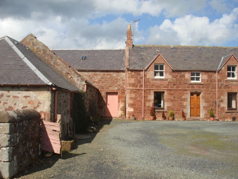
Possibly late 18th century with later additions and alterations. Symmetrical 2-storey, 3-bay house forming part of U-plan courtyard with flanking single storey ancillary structures projecting to SE; further single storey ancillary structures forming near T-plan complex adjoined to SW. Harl-pointed red sandstone rubble; tooled sandstone dressings. Predominantly droved rubble quoins; droved long and short surrounds to openings; projecting cills.
N RANGE, INCLUDING HOUSE, SE (ENTRANCE) ELEVATION: replacement timber panelled door centred at ground; squat single window aligned above; single windows at ground in flanking bays; gabled windows breaking eaves above. Lean-to porch adjoining single storey ancillary structure adjoined to right. Boarded timber door in 2-storey ancillary structure adjoined to left. NW (REAR) ELEVATION: irregularly fenestrated house at centre with gabled bipartite windows breaking eaves at 1st floor. Modern window in single storey ancillary structure adjoined to left. Boarded timber openings in both bays at both floors in 2-storey ancillary structure adjoined to right. Blind elevation to further single storey ancillary structure recessed to outer right.
E ANCILLARY STRUCTURE, SW (COURTYARD) ELEVATION: 2-bay wing to left with boarded timber doors in segmental-arched carriage openings; lean-to porch adjoined to outer left. Later (?) 2-bay piended addition to outer right with boarded timber doors in square-headed openings; boarded fanlights. NE (REAR) ELEVATION: blind.
W ANCILLARY STRUCTURE, NE (COURTYARD) ELEVATION: single bay wing to right with boarded timber door off-set to right of centre. Later (?) single bay piended addition to left with boarded timber door at centre; lean-to addition recessed to outer left with rubble-walled enclosure to front. SW (REAR) ELEVATION: blind elevation to left; small square-headed opening to right; lean-to addition to outer right.
ANCILLARY STRUCTURES TO SW, SE (FRONT) ELEVATION: T-plan complex comprising rectangular-plan, piend-roofed implement shed advanced at centre with square-headed opening to front. Full-width single storey range at rear with large, square-headed openings flanking centre. Tall, coped rubble wall enclosing yard to W.
Some 4-pane glazing in timber sash and case windows to house; some modern windows; small rooflights in ancillary structures. Grey slate roofs throughout; stone skews; cast-iron rainwater goods. Red brick apex stack to house (right stack missing); circular can; small brick-built ridge stack to E ancillary range.
INTERIORS: not seen 1998.
GARDEN WALLS: coped rubble walls partially enclosing site (modern in part).
An interesting and relatively intact mill steading complex set just inside Polwarth parish. Originally occupied by a miller and associated with the nearby, now ruinous "...small corn mill...propelled by the water of Langton Burn" (OS Name Book). The mill, mill ponds and mill lead are all shown on the early Ordnance Survey map.
External links are from the relevant listing authority and, where applicable, Wikidata. Wikidata IDs may be related buildings as well as this specific building. If you want to add or update a link, you will need to do so by editing the Wikidata entry.


Other nearby listed buildings
