Approximate Location Map
Large Map »
Latitude: 55.98 / 55°58'48"N
Longitude: -3.2161 / 3°12'58"W
OS Eastings: 324212
OS Northings: 677003
OS Grid: NT242770
Mapcode National: GBR 8J3.1T
Mapcode Global: WH6SD.KYQJ
Plus Code: 9C7RXQJM+2H
Entry Name: Wardie Hotel, 102 Lower Granton Road, Edinburgh
Listing Name: 102 Lower Granton Road, Wardie Hotel, with Yard Wall and Gatepiers
Listing Date: 25 February 2000
Category: C
Source: Historic Scotland
Source ID: 394096
Historic Scotland Designation Reference: LB46739
Building Class: Cultural
ID on this website: 200394096
Location: Edinburgh
County: Edinburgh
Town: Edinburgh
Electoral Ward: Forth
Traditional County: Midlothian
Tagged with: Hotel building
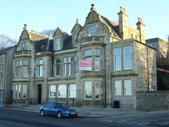
1881, reworking and extension of earlier fabric. 2-storey, 6-bay Jacobean-detailed hotel with attic storey. Squared and snecked pale sandstone with polished dressings; central 3 bays ashlar with cornice and blocking course. Stone mullions and transoms.
N (PRINCIPAL) ELEVATION: outer bays advanced, with 2-storey balustraded canted windows and curvilinear gables topped by ornate ball finials. 4-light windows to left, 3-light to right; corniced windows in gableheads, bipartite to left, single to right. Entrance in less advanced 2nd bay from left, with timber panelled door, plate glass fanlight and shoulder-arched door frame; window above with horizontal stone mullion. 3 central bays to right have Doric pillared loggia (filled in later and containing door to bar at left); 3 windows above, outer 2 single, inner double; tall dormers with finialled curvilinear gableheads. Later single storey extension to W.
E AND W ELEVATIONS: coursed sandstone rubble; metal fire escape to later extension in roof to W.
Grey slate roofs; ornamental wrought-iron cresting on ridge. Coped stone stacks with polished quoins; octagonal cans.
YARD WALL AND GATEPIERS: coursed rubble, stone-coped wall curves up to meet gatepier at left; ashlar gatepiers with ball finials on conical caps.
Mapwork and consultation with Edinburgh) confuse an apparently straightforward building history for this property. The building, with right-hand projecting bay, is clearly there on 1853 OS map, but on the 1896 OS the left bay does not appear to be there. EDINBURGH says it has 'a nicely detailed baronial extension by Reid and Forbes, 1935,' but there is no ground on which this could have been built, nor any sign of demolition; certainly it is no longer there.
External links are from the relevant listing authority and, where applicable, Wikidata. Wikidata IDs may be related buildings as well as this specific building. If you want to add or update a link, you will need to do so by editing the Wikidata entry.


Other nearby listed buildings
