Approximate Location Map
Large Map »
Latitude: 55.9554 / 55°57'19"N
Longitude: -2.9746 / 2°58'28"W
OS Eastings: 339243
OS Northings: 674022
OS Grid: NT392740
Mapcode National: GBR 2J.XX96
Mapcode Global: WH7TV.8KSX
Plus Code: 9C7VX24G+45
Entry Name: Pavilion, Polwarth Playing Fields, Prestonpans
Listing Name: Preston, Polwarth Playing Field Pavilion
Listing Date: 29 March 2000
Category: C
Source: Historic Scotland
Source ID: 394393
Historic Scotland Designation Reference: LB47013
Building Class: Cultural
ID on this website: 200394393
Location: Prestonpans
County: East Lothian
Electoral Ward: Preston, Seton and Gosford
Parish: Prestonpans
Traditional County: East Lothian
Tagged with: Pavilion
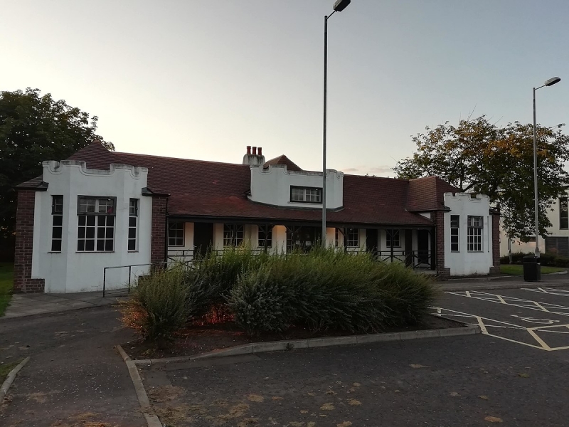
Earlier 20th century, with later addition to rear. Single storey and attic playing field pavilion. Rendered and whitewashed, with red brick detailing. Deep brick base course.
S (PRINCIPAL) ELEVATION: 9-bay, comprising advanced 3-light canted centre and outer bays, with crenellated blocking courses, breaking eaves, centre bay breaking pitch with bipartite window centred at attic. Steps to central 7 bays; timber doors flanked by single windows, flanking advanced centre bay, overhanging eaves forming loggia.
E ELEVATION: 4-bay, bays divided by vertical brick bands. Pair of small windows in bays flanking centre.
N (REAR) ELEVATION: obscured by wall. 3 small windows, evenly arranged, in bay to outer left; projecting central bay, with small window to right of centre. Single storey addition to right.
W ELEVATION: not seen, 2000.
Variety of metal (?) windows. Red pantile roof; terracotta ridge. Stylised wallhead stack centred and breaking pitch at N elevation; brick coped, with circular can. Cast-iron rainwater goods.
INTERIOR: not seen, 2000.
Polwarth Playing Field Pavilion is of interest for its 1930's detailing. During the 1930's there was a social trend towards health and the outdoors, primarily to combat the growth of infectious diseases.
External links are from the relevant listing authority and, where applicable, Wikidata. Wikidata IDs may be related buildings as well as this specific building. If you want to add or update a link, you will need to do so by editing the Wikidata entry.


Other nearby listed buildings
