Approximate Location Map
Large Map »
Latitude: 55.6095 / 55°36'34"N
Longitude: -4.4971 / 4°29'49"W
OS Eastings: 242806
OS Northings: 637934
OS Grid: NS428379
Mapcode National: GBR 3G.MQRC
Mapcode Global: WH3Q9.W8PH
Plus Code: 9C7QJG53+R5
Entry Name: Bridge, Kilmarnock Water, Sandbed Street, Kilmarnock
Listing Name: Sandbed Street, Sandbed Bridge
Listing Date: 1 August 2002
Category: C
Source: Historic Scotland
Source ID: 396271
Historic Scotland Designation Reference: LB48782
Building Class: Cultural
ID on this website: 200396271
Location: Kilmarnock
County: East Ayrshire
Town: Kilmarnock
Electoral Ward: Kilmarnock West and Crosshouse
Traditional County: Ayrshire
Tagged with: Bridge
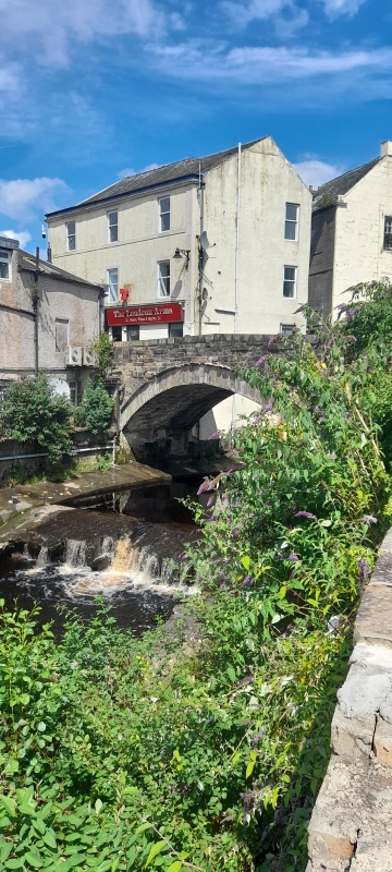
1762; later addition and repairs. Single span, segmental-arched bridge Coursed sandstone ashlar of varying colours, inset ashlar voussoirs; coursed tooled and droved rubble parapet.
NE AND SW ELEVATIONS: abutments concealed by later coursed rubble and brick retaining walls of buildings adjoining riverside; single segmental arch with slightly recessed ashlar voussoirs breaking into parapet, coursed ashlar and rubble spandrels; drip mould leading to slightly recessed rubble parapet, flush rectangular copes surmounting.
NW & SE ELEVATIONS: fairly narrow tarmac road with parapet sides joining Sandbed Street to the junction of Strand and Bank Streets.
Sometimes referred to as the "Old Bridge" or "Town Bridge", Sandbed is the oldest bridge in Kilmarnock. It stands over the Kilmarnock Water and links Cheapside and Bank Street with the Sandbed (Street). When Timothy Pont visited Kilmarnock in 1612, he described its predecessor as "a faire stone bridge" but by 1658 Richard Franck thought it to be "wretchedly ancient". A new bridge followed and was repaired in 1753 after a devastating flood. This "new" bridge was constructed and it carried the main Glasgow Road through the town before King Street was opened up. It was also the venue for the town's market until the Flesh Market Bridge (on the site of the present Burn's Mall) was constructed in 1770. An enclosed bridge can be viewed to the NE, this carries King Street to The Cross and has a row of shops (formerly Victoria Place) on it. A sculpture of a swimmer and fish can be seen on the pavement of King Street marking the spot where the Kilmarnock Water passes beneath.
External links are from the relevant listing authority and, where applicable, Wikidata. Wikidata IDs may be related buildings as well as this specific building. If you want to add or update a link, you will need to do so by editing the Wikidata entry.


Other nearby listed buildings
