Approximate Location Map
Large Map »
Latitude: 55.8635 / 55°51'48"N
Longitude: -5.4134 / 5°24'48"W
OS Eastings: 186504
OS Northings: 668632
OS Grid: NR865686
Mapcode National: GBR FF06.WNW
Mapcode Global: WH0K3.TWDC
Plus Code: 9C7PVH7P+9M
Entry Name: Weighbridge Cottage, Tarbert Harbour
Listing Name: Tarbert Harbour Walls Including Former Weighbridge, Slipways and Beilding
Listing Date: 1 October 2002
Category: B
Source: Historic Scotland
Source ID: 396449
Historic Scotland Designation Reference: LB48935
Building Class: Cultural
ID on this website: 200396449
Location: Kilcalmonell
County: Argyll and Bute
Electoral Ward: Kintyre and the Islands
Parish: Kilcalmonell
Traditional County: Argyllshire
Tagged with: Cottage
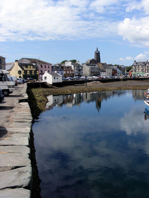
Thomas Telford, engineer, early 19th century. Near U-plan harbour. Dry stone rubble wall. Steps within wall to E; rear wall of former weighbridge building extends beyond harbour wall with slipway to E. Weighbridge comprised of gabled cottage (now commercial premises); harled with slate roof, gablehead stacks; 2 windows to N, window to each gable, central door with flanking windows to S. Rear (N) wall extending down to lower ground of slip. Further slipway to SW. 2 archways within SW corner of harbour wall (for drainage); wall continues northwards with steps within wall. Harbour walls terminating to N at slipway and to E at pier. Square quay (Beilding) within harbour; dry stone rubble; stone steps within wall to SE.
Tarbert Harbour is depicted on a plan in Atlas to the Life of Telford, that features a number of harbours, which were 'made or improved under the direction of The Commissioners for Highland Roads and Bridges 1806-1821.' This was part of a huge programme of canal, road and bridge construction in the Highlands which was set up by the government to alleviate
social problems by improving communication. The plan shows the 2 slipways and a pier to the East. This pier has been added to a number of times to create Harbour Street and is not part of the statutory list. Other references suggest that Telford's harbour improvements took place in the second half of the 19th century. Tarbert Harbour is a natural harbour and is situated at the head of East Loch Tarbert. The herring fishing industry developed here during the 18th and early 19th centuries. As it did so, the village grew (many of the waterfront buildings date from the early 19th century) and Tarbert became the centre of the Loch Fyne
herring fishery. The square quay (Beilding) is an artificial island, which was used to help haul sailing boats into the harbour during times of difficult winds. (RCAHMS).
External links are from the relevant listing authority and, where applicable, Wikidata. Wikidata IDs may be related buildings as well as this specific building. If you want to add or update a link, you will need to do so by editing the Wikidata entry.


Other nearby listed buildings
