Approximate Location Map
Large Map »
Latitude: 55.9253 / 55°55'30"N
Longitude: -4.406 / 4°24'21"W
OS Eastings: 249764
OS Northings: 672859
OS Grid: NS497728
Mapcode National: GBR 0T.ZL53
Mapcode Global: WH3NT.9B5G
Plus Code: 9C7QWHGV+4J
Entry Name: Duntocher Free Church, Glasgow Road, Duntocher
Listing Name: Hardgate, 13 Glasgow Road, Hardgate Hall (Former Duntocher Free Church)
Listing Date: 27 September 2004
Category: C
Source: Historic Scotland
Source ID: 397707
Historic Scotland Designation Reference: LB49986
Building Class: Cultural
ID on this website: 200397707
Location: Clydebank
County: West Dunbartonshire
Town: Clydebank
Electoral Ward: Kilpatrick
Traditional County: Dunbartonshire
Tagged with: Church building Church hall
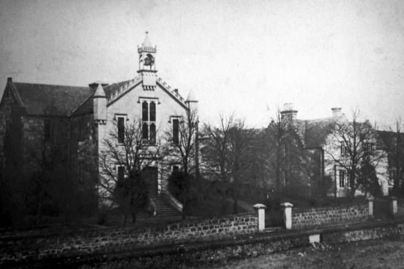
1844-1845. 2-storey, 3-bay, T-plan Gothic revival church with projecting transepts; later 19th century addition to N (rear). Droved ashlar to S (principal elevation); coursed rubble to sides and rear. Raised ashlar strip quoins; raised ashlar margins; stone cills; wide ashlar basecourse; moulded eavescourse. Square moulded hoodmoulds to S openings. Corniced square slightly advance doorpiece with elliptical arched opening and Gothic mouldings; moulded crenellated parapet; corniced mock-bartizans with large guttae. Stone steps and coped boundary wall rising to main entrance.
S (PRINCIPAL) ELEVATION: central advanced carved doorpiece; flanking narrow windows. Large central 1st floor window; flanking tall narrow windows. Slightly advance corniced pedestal with Gothic arched mouldings and large guttae to gablehead (formally carrying bellcote).
E ELEVATION: 3 bays. Advanced gabled bay to right (transept); bipartite windows. Later 19th century single storey, 3-bay pitched roof extension recessed to far right; lean-to lavatory extension to right re-entrant angle.
N (REAR) ELEVATION: 3 wide bays. Later 19th century single storey, pitched roof extension recessed to centre. Bipartite windows (trefoil windows at 1st floor, centre).
W ELEVATION: similar to E elevation.
Predominantly 3-pane timber sash and case windows. Pitched roofs; grey slates; castellated and triangular stone skews.
INTERIOR: slender cast-iron Doric columns. Gallery to S. Derelict (2004)
A well-detailed church, in a prominent location. Sitting next to the original Free Church manse (to E), this building forms a good group of historic buildings near Hardgate Cross. Early 19th century buildings of Strang's Lands and Haldane's Lands (now Park View) are also found near the Cross. The church is set on a raised site, formerly surrounded by dam water which serviced the local wool and cotton industries during the 19th century. A bellcote formerly rested on gable apex to the S principal elevation and the corner bartizans held tall stone pyramidal caps. In 1900, the church was known as the United Free Church; in 1929 it became a Church of Scotland. The building ceased being used as a church in 1958. Latterly the building was used as a hall and is presently unoccupied (2004).
External links are from the relevant listing authority and, where applicable, Wikidata. Wikidata IDs may be related buildings as well as this specific building. If you want to add or update a link, you will need to do so by editing the Wikidata entry.


Other nearby listed buildings
