Approximate Location Map
Large Map »
Latitude: 56.2724 / 56°16'20"N
Longitude: -2.606 / 2°36'21"W
OS Eastings: 362566
OS Northings: 709048
OS Grid: NO625090
Mapcode National: GBR 2Z.8VW5
Mapcode Global: WH8TL.YL6V
Plus Code: 9C8V79CV+XH
Entry Name: Control Tower
Listing Name: Crail Airfield, Technical Area, Control Tower, No 62565 09048
Listing Date: 25 August 2006
Category: A
Source: Historic Scotland
Source ID: 398837
Historic Scotland Designation Reference: LB50552
Building Class: Cultural
ID on this website: 200398837
Location: Crail
County: Fife
Electoral Ward: East Neuk and Landward
Parish: Crail
Traditional County: Fife
Tagged with: Architectural structure
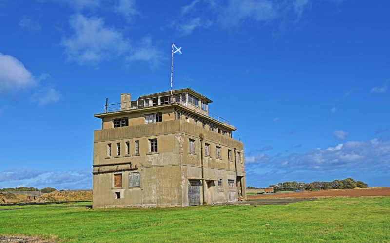
1939-40. 3-storey rectangular plan flat-roofed former Control Tower with reduced 3rd storey to accommodate observation walkway and further small upper observation deck. Incorporates crash tender garage to S elevation. Smooth cement rendered brick. Multi-pane metal casement windows. Interior room plan extant. Concrete stair with timber handrail.
All listings at Crail Airfield are Group Category A. The Runways are designated as a Scheduled Ancient Monument.
The Control Tower is noted as building number 1 on the DTZ/LDN report.
The Crail Control Tower is a particularly rare survival. The general design is unique to Naval Air Stations. Only 2 of this particular type, with an incorporated ambulance and crash tender garage to the ground floor, are thought to have been constructed. The other example, at RM Condor in Arbroath, has been altered and the Crail building is therefore the best example of its type.
Crail Airfield is the best preserved example of a Second World War Naval Airfield in Scotland. It is remarkable for its survival, completeness and the rarity of some of the individual buildings. It is highly significant not only in the wider terms of Naval and Second World War history, but is also of great local importance. Crail was one of 4 airfields constructed in the early war period (along with Arbroath in Angus, Yeovilton in Somerset, and St Merryn in Cornwall). It follows the Naval pattern of 4 narrow hard runways and associated brick, concrete and corrugated iron structures. The runways are part of the main operational side, the 'Technical Area' to the South-East. The recreation and living quarters of the 'West Camp' are located to the North-West. These areas are separated by the road between Crail and Balcomie. The aircraft hangars and the great majority of the interiors are the most significant losses at the site. Many buildings have been altered and are in a poor state of repair. Around 2000 personnel were stationed at Crail Airfield, both living at the airfield itself and billeted in Crail and the surrounding area.
An airfield operated briefly at Crail in 1918 during the First World War. It was closed in 1919 and no buildings from this period are thought to survive. The site was re-acquired in 1938 and construction of a new airfield began in 1939. In 1940 the site was commissioned as the Royal Naval Air Station HMS Jackdaw and functioned as the main Fleet Air Arm base for training pilots in torpedo warfare. Crail housed 785, 786 and 711 Squadrons and was never a permanent home to an active front line squadron. At Crail pilots were taught the art of flying low over the water, dropping dummy and live torpedoes. The last permanently based aircraft left the base in 1947 and the site became HMS Bruce - the Royal Navy Boys' Training Facility until 1949. It was subsequently an Army Transit Camp (including a mobilisation base for the Black Watch 1952-4) from 1950-4 and served as the Joint Services School for Linguistics during the period 1955-60. The site was then sold and the majority of the buildings were adapted for pig farming. Some farming still takes place along with car boot sales and amateur car racing events (2006). The majority of the airfield was scheduled as an ancient monument in 1997 and this was reviewed in 2006 with a reduced area of scheduling covering the runways and selective listing of the built structures.
External links are from the relevant listing authority and, where applicable, Wikidata. Wikidata IDs may be related buildings as well as this specific building. If you want to add or update a link, you will need to do so by editing the Wikidata entry.


Other nearby listed buildings
