Approximate Location Map
Large Map »
Latitude: 55.1788 / 55°10'43"N
Longitude: -2.8134 / 2°48'48"W
OS Eastings: 348296
OS Northings: 587470
OS Grid: NY482874
Mapcode National: GBR 88SK.PB
Mapcode Global: WH7YS.R3G5
Plus Code: 9C7V55HP+GJ
Entry Name: Buccleuch Centre, 4 South Hermitage Street (Corner With Union Street)
Listing Name: Newcastleton, 4 South Hermitage Street (Corner with Union Street), Buccleuch Centre
Listing Date: 7 November 2007
Category: C
Source: Historic Scotland
Source ID: 399786
Historic Scotland Designation Reference: LB51013
Building Class: Cultural
ID on this website: 200399786
Location: Castleton
County: Scottish Borders
Electoral Ward: Hawick and Hermitage
Parish: Castleton
Traditional County: Roxburghshire
Tagged with: House
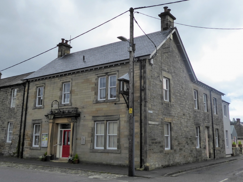
Attributed to James Burnet, 1896. 2-storey, 3-bay, gabled former clubhouse with central pilastered doorway and bracketed eaves. Coursed sandstone with polished ashlar dressings. Base course. Regular fenestration with raised margins; stone-mullioned bipartite windows to right-hand bay; raised quoin strips. 3 steps to central timber-panelled front door with side lights, recessed within deep pilastered architrave. Bracketed clock to outer right.
4-pane glazing in timber sash and case windows. Corniced gablehead stacks. Grey slate roof.
A good late 19th century clubhouse, prominently positioned close to the heart of Newcastleton. It was designed by the Duke of Buccleuch's architect, presumably James Burnet Buildings of Scotland attribution. Burnet was a Langholm-based architect whose known works are predominantly churches and schools. He died in 1898, making this a late work if it is indeed by him. The clubhouse is not shown on the 2nd edition Ordnance Survey map (1896-8). Newcastleton Village was laid out from 1793 by Henry, 3rd Duke of Buccleuch, to his own plan, as a centre for handloom weaving.
External links are from the relevant listing authority and, where applicable, Wikidata. Wikidata IDs may be related buildings as well as this specific building. If you want to add or update a link, you will need to do so by editing the Wikidata entry.


Other nearby listed buildings
