Approximate Location Map
Large Map »
Latitude: 55.3295 / 55°19'46"N
Longitude: -3.4447 / 3°26'41"W
OS Eastings: 308439
OS Northings: 604893
OS Grid: NT084048
Mapcode National: GBR 46DT.0B
Mapcode Global: WH6WL.19XN
Plus Code: 9C7R8HH4+R4
Entry Name: Timber Pavilion, Station Park
Listing Name: Station Park, Timber Pavilion
Listing Date: 16 September 2010
Category: C
Source: Historic Scotland
Source ID: 400489
Historic Scotland Designation Reference: LB51589
Building Class: Cultural
ID on this website: 200400489
Location: Moffat
County: Dumfries and Galloway
Town: Moffat
Electoral Ward: Annandale North
Traditional County: Dumfriesshire
Tagged with: Architectural structure
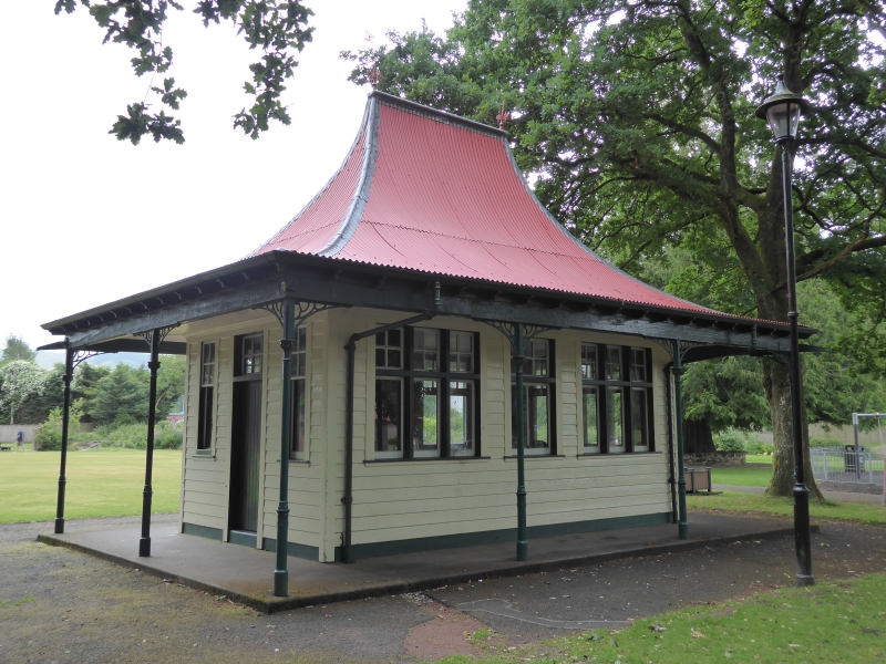
Early 20th century. Distinctive, near-square-plan, symmetrical, 3-bay, single-storey timber pavilion, surrounded by verandah and with high, steeply pitched, sweeping bellcast roof, situated within public park. Painted clapboard with contrasting painted margins. Some tripartite windows with timber transoms and mullions. Part-glazed timber door with 6-pane fanlight above. Verandah with overhanging eaves and valance supported by slender cast-iron bracketed columns. Pair of wrought iron finials to roof apex.
4-pane top hoppers over plate glass timber windows with external secondary glazing. Red corrugated iron roof.
INTERIOR: (seen 2010). Large vertical timber boarded room with slatted timber benches. Smaller room to W.
This little altered timber pavilion is an eye-catching and distinctive architectural feature situated within the Station Park. The dramatic sweep of the roof and the surrounding verandah are distinctive elements of this unusual building. The timber boarded interior has also been retained.
Station Park was created towards the end of the 19th century and is depicted on the 2nd Edition Ordnance Survey Map of 1900 with meandering paths and a pond to the South. Public parks were a popular part of urban planning in the late 19th century. This pavilion first appears on the 1938 Map, and it is unclear exactly what its original function was, although it is likely to have been covered place for sitting. Architectural features were important elements of landscaped parks, both public and private and the unusual design of this one distinguishes it in its current setting.
External links are from the relevant listing authority and, where applicable, Wikidata. Wikidata IDs may be related buildings as well as this specific building. If you want to add or update a link, you will need to do so by editing the Wikidata entry.


Other nearby listed buildings
