Approximate Location Map
Large Map »
Latitude: 59.0841 / 59°5'2"N
Longitude: -3.2766 / 3°16'35"W
OS Eastings: 326936
OS Northings: 1022606
OS Grid: HY269226
Mapcode National: GBR L48Q.HRJ
Mapcode Global: WH698.MXXY
Plus Code: 9CFR3PMF+J9
Entry Name: Pillbox, Twatt Airfield (Former Hms Tern)
Listing Name: Twatt Airfield (Former Hms Tern), Pillboxes
Listing Date: 15 July 2011
Category: C
Source: Historic Scotland
Source ID: 401676
Historic Scotland Designation Reference: LB51782
Building Class: Cultural
ID on this website: 200401676
Location: Birsay and Harray
County: Orkney Islands
Electoral Ward: West Mainland
Parish: Birsay And Harray
Traditional County: Orkney
Tagged with: Architectural structure
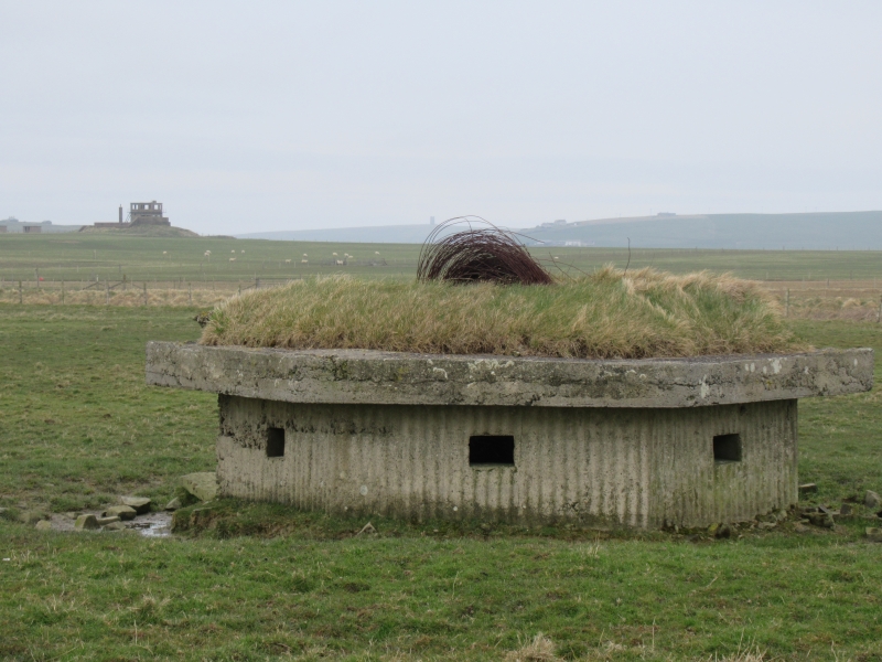
1941-43. Pair of partially dug-in, hexagonal, WWII pillboxes with grass roof coverings located at S and E perimeters of former Royal Naval Air Service (RNAS) set in open landscape comprising Twatt Airfield (former HMS Tern). Brick and shuttered concrete construction with overhanging flat roof; small square loophole to each elevation.
Part of a B Group at Twatt Airfield including: Combined Control Tower and Operations Block; 5 Air-Raid Shelters; 2 Pillboxes (see separate listings).
This pair of concrete WWII pill-boxes at the former Twatt Airfield are a good contextual survival within their building type. Situated at the southern and eastern perimeters of the airfield, the roofs of the hexagonal pillboxes are grass-covered as a camouflage measure. Corrugated sheeting has been used to shutter the concrete giving the pillboxes a distinctive appearance. The pillboxes are positioned to provide interlocking fields of fire over the anticipated southerly direction of attack. The loopholes are angled to limit access of incoming fire.
Twatt Airfield was an important Second World War Naval airfield in Orkney. Begun in 1940 and commissioned as HMS Tern in 1941 as a satellite of Hatston airfield for the Royal Marine engineers, it remained in service until 1949. The interest of the shelters is increased by the survival of various other associated WWII structures at Twatt, largely in shell form. The combined control tower and operations block (see separate listing) is the principal building of note. Of the four main military airfields in Orkney, Twatt has the most complete level of surviving WWII infrastructure with little now remaining at Hatston, Skeabrae or Grimstter (Kirkwall). The surviving elements include 5 air-raid shelters (see separate listing), the brick shells of the vehicle and parachute stores, ammunition stores, sick bay/decontamination unit and generator house and the projection room section of the former cinema. None of the aircraft hangars remain.
Air defences in Orkney were a significant contributor to national security with strikes from airfields in Orkney countering U-boat, surface vessel and air threats over the North Sea and at Scapa Flow. The hub of the Royal Navy's sea base operations were located at Lyness at the entrance to Scapa Flow including the Wee Fea Naval Communications and Operational Centre (see separate listing).
The airfield covered 440 acres of land in 1941 and was extended to a total of 564 acres in 1943. There are three adandoned 19th century farmsteads within the perimeter. Royal Navy Air Stations were separate from the Air Ministry and therefore developed their own distinct airfield architecture and layout, tending to have 4 intersecting runways rather than the 'A' plan layout favoured by the Air Ministry (RAF).
External links are from the relevant listing authority and, where applicable, Wikidata. Wikidata IDs may be related buildings as well as this specific building. If you want to add or update a link, you will need to do so by editing the Wikidata entry.


Other nearby listed buildings
