Approximate Location Map
Large Map »
Latitude: 56.0135 / 56°0'48"N
Longitude: -5.446 / 5°26'45"W
OS Eastings: 185295
OS Northings: 685426
OS Grid: NR852854
Mapcode National: GBR DDYT.D7G
Mapcode Global: WH0JJ.93XS
Plus Code: 9C8P2H73+CH
Entry Name: Ardrishaig, Pier Square, Canal Office
Listing Name: Canal Office, Pier Square, Ardrishaig
Listing Date: 19 June 2014
Category: C
Source: Historic Scotland
Source ID: 402325
Historic Scotland Designation Reference: LB52223
Building Class: Cultural
ID on this website: 200402325
Location: South Knapdale
County: Argyll and Bute
Electoral Ward: Mid Argyll
Parish: South Knapdale
Traditional County: Argyllshire
Tagged with: Architectural structure
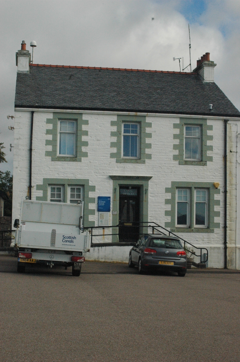
Mid 19th century. 2-storey, 3-bay Canal Office with separate, former keeper's accommodation at first floor. Rubble with in-and-out ashlar dressings. Base course and moulded eaves course. Steps to stop-chamfered and corniced door-piece to centre with bipartite windows to right and left. Upper floor level is accessed separately by door to left side of south gable. Replacement timber sash and case windows with 4-pane glazing to upper sash. Grey slate. Coped end stacks with clay cans.
INTERIOR: seen 2013. Glazed vestibule. Principal ground floor room with large metal walk-in safe. The upper floors of the building are accessed via the door to the south west gable. Room to west retains an early 20th century kitchen range.
The Canal Office at Ardrishaig is an integral part of the infrastructure of the Crinan Canal - a landmark sea-to-sea canal in the west of Scotland and one of five surviving canals in country, each having its own character and interest. Included in the interior is a large walk-in safe on the ground floor, the Canal Office was built as part of 19th century changes to the operation of the Crinan Canal involving an increase in tolls and pier dues, resulting from increased canal traffic and trading during the period.
Prominently located at Pier Square near the harbour at Ardrishaig (see separate listing), the Canal Office groups well with the passenger steamer building adjacent and the interest of the buildings is increased further by their contextual association with the adjacent canal. It is depicted clearly on the 1865 Ordnance Survey map, occupying the same location as the Lock-keeper's House shown on engineer David Smith's map of the canal dated 1823.
The first floor, with separate access, was originally canal keeper's accommodation. It has now been converted to office and meeting space with some features, including the range in the former kitchen, retained. It survives largely unaltered externally and remains in use for its intended purpose.
The canal itself, tow path and the bridges that cross it (excluding modern road surfaces) and a number of other associated structures are a Scheduled Monument. See Scheduled Monument No 6501 for full details.
The Crinan Canal was one of more than 50 canals projects approved in Britain between the years 1790 and 1794. This intense period of canal building dramatically increased the opportunities for trade arising from the new industries of the period and decisively ended the situation in which heavy materials could only be moved short distances without the aid of navigable rivers or coastal transport.
Taking its name from the village at its north-westerly end, the canal is 14 kilometers long, rising and falling through 15 locks. It was built to stimulate trade between the Clyde area and the Inner Hebrides by avoiding the 130 kilometer journey around the Kintyre peninsula. The canal transported numerous freights, particularly slate from the north, coal from the south and services including postal and passenger traffic.
The Crinan Canal is renowned for its striking landscape and scenic variation over its relatively short length. The canal-side buildings are largely 19th century with simple detached cottages defining the small number of settlements along the route. The canal had a long and troubled development history with shortages of labour, building materials, structural issues and related financial concerns. The perseverance needed to complete and continue to maintain the canal despite these set-backs, amid the evolving industrial and commercial landscape of the 19th century, are part of the canal's significance.
Engineer James Watt had surveyed possible routes for the canal as early as 1771. James Rennie proposed an alternative route in 1793 and work began the following year and the canal opening to traffic in 1801. Under the advice of pre-eminent Scottish engineer Thomas Telford, a major refurbishment of the canal was undertaken in 1817, funded by the Government. Telford's recommendations resulted in a complete overhaul at a cost of over 18000 pounds. Substandard stonework, lock gates and bridges were repaired or replaced, banks were raised, bends straightened and rocks removed to level the canal bed. The canal effectively came into public ownership after these works were complete.
Traffic through the Crinan increased considerably after the opening of Telford's Caledonian Canal in 1822. Using both canals, boats could now travel from Glasgow to Inverness. Queen Victoria navigated the Crinan Canal in 1847 and passenger steamer companies were quick to advertise a 'Royal Route'. By 1866 a specially designed Canal steamer called The Linnet was introduced to help cope with the increasing passenger numbers. The Linnet remained in service for the next 65 years. Between 1930 and 1932, new sea locks were built at either end of the Crinan Canal, making it accessible at any tide. The Canal has continued to operate as a centre for tourism in the area into the 21st century with around 2000 yachts, fishing boats and pleasure cruisers travelling through its locks each year.
Listed as part of the Scottish Canals estate review 2013-2014.
External links are from the relevant listing authority and, where applicable, Wikidata. Wikidata IDs may be related buildings as well as this specific building. If you want to add or update a link, you will need to do so by editing the Wikidata entry.


Other nearby listed buildings
