Approximate Location Map
Large Map »
Latitude: 57.4648 / 57°27'53"N
Longitude: -4.2436 / 4°14'36"W
OS Eastings: 265518
OS Northings: 843831
OS Grid: NH655438
Mapcode National: GBR H8WZ.YQJ
Mapcode Global: WH3FB.SMFS
Plus Code: 9C9QFQ74+WH
Entry Name: Inverness, Caledonian Canal, Tomnahurich Bridge Keeper's Cottage
Listing Name: Tomnahurich Bridge Keeper's Cottage, Caledonian Canal, Inverness
Listing Date: 19 June 2014
Category: C
Source: Historic Scotland
Source ID: 402331
Historic Scotland Designation Reference: LB52230
Building Class: Cultural
ID on this website: 200402331
Location: Inverness
County: Highland
Town: Inverness
Electoral Ward: Inverness West
Traditional County: Inverness-shire
Tagged with: Architectural structure
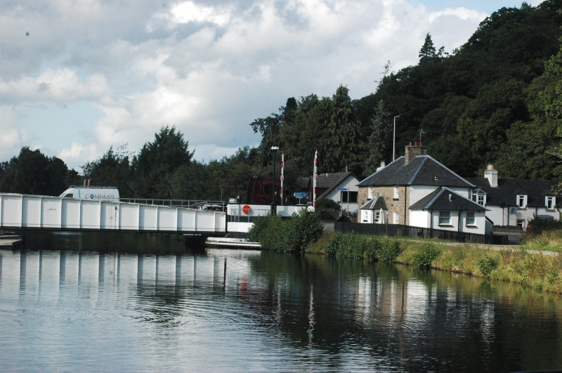
Circa 1820. 2-storey, 3-bay former bridge keeper's cottage symmetrical and rectangular in plan, with a piended roof and central piended porch. The cottage faces the Caledonian Canal and sits adjacent to the Tomnahurich swing bridge. It is constructed predominantly of coursed sandstone rubble with irregular dressed quoins and rybats, and has slate roof coverings throughout. There is a lean-to extension to the south gable and entrance door to the east. The property is enclosed to the north by a rubble coped garden wall and to the west by a wooden picket fence.
There is predominantly replacement 4-pane glazing in timber sash and case frames. There is a single window to each level of the north gable and a large central stack with clay cans and a slate roof with lead flashings.
The interior has been modernised to provide self-catering accommodation.
This is a good example of a former bridge keeper's cottage and is likely to date to 1820, when the first Tomnahurich Bridge was constructed. Bridge Keeper's cottages are an integral and important part of the Caledonian Canal, which at the time of its construction was the largest canal in the United Kingdom. The setting of Tomnahurich Bridge Keeper's cottage has not changed greatly since it was built and this adds interest to the building as it retains its functional relationship to the nearby canal and swing bridge. The exterior of the cottage is largely unaltered, with the exception of an extension to the rear and side. The single window to each gable offers views along the canal of approaching traffic. The bridge is a major thoroughfare in the area, presently carrying traffic along the main A82 road from Inverness to Fort William and the west coast.
The original timber Tomnahurich swing bridge was replaced in 1938 with the current metal swing bridge, designed by Crouch and Hogg in 1937, and a control box was added, both to cope with increasing road and marine traffic. According to Canmore records, the house became disused in around 1965 as bridge keepers were no longer required to be resident adjacent to their bridges, and it lay empty for several years. The metal swing bridge and control box add to the group value of this former bridge keeper's cottage and together they form a contextually and functionally related group.
The primary role of a bridge keeper was to maintain and operate the swing bridges and cottages were constructed adjacent to the bridge for convenience. Cottages were usually single storey with accommodation comprised of a living room and a bedroom, and sometimes with a small outshot to the rear, used as a scullery. At Tomanahurich the cottage was built over two storeys. As living standards improved these outshots have generally been enlarged for increased kitchen and bathroom accommodation, and this is evident at Tomnahurich Bridge Keeper's Cottage. The cottages were often set in gardens to grow vegetables and keep poultry and animals.
The whole of the Caledonian Canal is a Scheduled Monument which identifies it as being of national importance to Scotland. For this section of the Caledonian Canal see Scheduled Monument No 6499.
The Caledonian Canal is one of five canals surviving in Scotland but is unique among them as being the only one entirely funded by public money. The canal was part of a wider infrastructure initiative across the Highlands to facilitate trade and the growth of industry and, most importantly for the Government, to tackle the emigration problem resulting from the Highland Clearances, by providing much-needed employment. The experienced engineer Thomas Telford submitted a report in 1802 to Government commissioners which detailed the route and size of the canal. The canal connects Inverness in the north to Corpach, near Fort William in the west, by linking four lochs: Loch Dochfur, Loch Ness, Loch Oich and Loch Lochy. The total length of the canal is 60 miles, but only 22 miles are man-made.
Built to take sea-going ships, including the 32-gun and 44-gun frigates of the Royal Navy, the Caledonian Canal was designed on a much larger scale than other canals in Britain and the locks were the largest ever constructed at that time. This combined with the remoteness of the location and the variable ground conditions, make it a great feat of engineering and construction.
Telford was appointed principal engineer to the commission with William Jessop as consulting engineer. Although work began in 1804 rising costs and the scale of the project resulted in slow progress and the first complete journey was made on 23-24 October 1822. Whilst the Canal was constructed for commercial use it was never a commercial success. Since its opening it was beset by problems and had to be closed for repairs and improvements in the 1840s. However the canal became popular with passenger steamers with tourism increasing following a visit by Queen Victoria on 16 September 1873.
Listed as part of the Scottish Canals estate review (2013-14).
External links are from the relevant listing authority and, where applicable, Wikidata. Wikidata IDs may be related buildings as well as this specific building. If you want to add or update a link, you will need to do so by editing the Wikidata entry.


Other nearby listed buildings
