Approximate Location Map
Large Map »
Latitude: 55.9375 / 55°56'15"N
Longitude: -3.1712 / 3°10'16"W
OS Eastings: 326934
OS Northings: 672228
OS Grid: NT269722
Mapcode National: GBR 8TM.41
Mapcode Global: WH6ST.8141
Plus Code: 9C7RWRQH+2G
Entry Name: 71 Dalkeith Road, Edinburgh
Listing Name: 71 Dalkeith Road, Including Boundary Walls and Pedestrian Gate, Edinburgh
Listing Date: 14 December 1970
Last Amended: 17 July 2015
Category: C
Source: Historic Scotland
Source ID: 405394
Historic Scotland Designation Reference: LB28616
Building Class: Cultural
ID on this website: 200405394
Location: Edinburgh
County: Edinburgh
Town: Edinburgh
Electoral Ward: Southside/Newington
Traditional County: Midlothian
Tagged with: Architectural structure
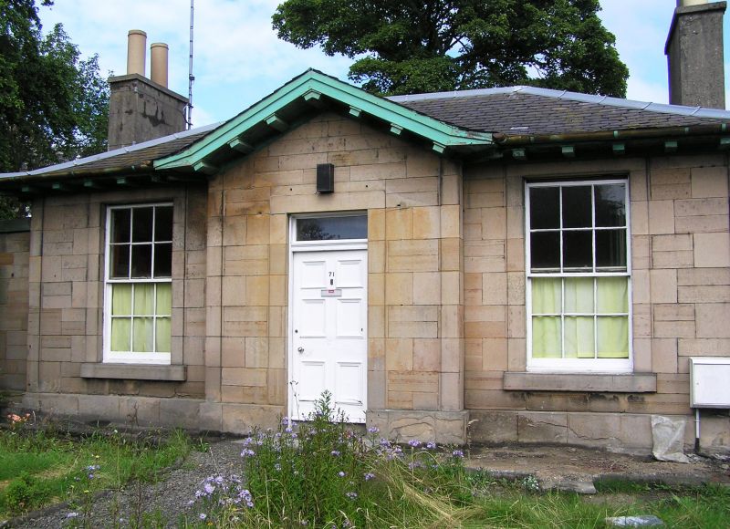
W (ENTRANCE) ELEVATION: central doorway; panelled door; plate glass fanlight; single windows in bays to outer left and right and to single storey wings.
Predominantly 12-pane, timber, sash and case windows; plate glass to single storey wing to S. Grey slate piended roof; tall, rendered and coped wallhead stacks; moulded cans.
INTERIOR: not seen 1995.
BOUNDARY WALLS AND PEDESTRIAN GATE: low coped rubble wall to street; railings removed; higher rubble mutual wall to S; N boundary wall incorporating window of adjoining house; pedestrian gate adjoining single storey wing to S.
Following the completion of the South Bridge in 1788, which linked the northern New Town and the Southside of Edinburgh, residential development to the south of Edinburgh expanded considerably. The lands of Newington were developed from the late eighteenth century as a residential suburb, comprising mainly detached villas.
The house at 71 Dalkeith Road first appears on the Ordnance Survey map of 1852 on a site formerly known as Rosehall.
Listed building record and statutory address updated (2015). Previously listed as '71 Dalkeith Road including boundary walls and pedestrian gate'.
External links are from the relevant listing authority and, where applicable, Wikidata. Wikidata IDs may be related buildings as well as this specific building. If you want to add or update a link, you will need to do so by editing the Wikidata entry.


Other nearby listed buildings
