Approximate Location Map
Large Map »
Latitude: 55.9001 / 55°54'0"N
Longitude: -3.2948 / 3°17'41"W
OS Eastings: 319133
OS Northings: 668203
OS Grid: NT191682
Mapcode National: GBR 50F6.GT
Mapcode Global: WH6SR.CY8R
Plus Code: 9C7RWP24+33
Entry Name: Millbank, 33 Lanark Road West, Currie, Edinburgh
Listing Name: Millbank including outbuilding to east and excluding conservatory to rear, 33 Lanark Road West, Currie, Edinburgh
Listing Date: 29 November 1988
Last Amended: 26 September 2016
Category: C
Source: Historic Scotland
Source ID: 406503
Historic Scotland Designation Reference: LB6122
Building Class: Cultural
ID on this website: 200406503
Location: Currie
County: Edinburgh
Electoral Ward: Pentland Hills
Parish: Currie
Traditional County: Midlothian
Tagged with: Villa
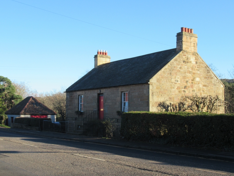
Millbank is built of coursed rubble with droved sandstone dressings. The building faces a main road on a triangular site of steeply sloping ground bordered to the rear by a side road. There is a later 19th century single storey square plan outbuilding to the east of the house.
The principal (north) elevation has a regular window pattern with an ashlar band course between the ground and first floors and an eaves course. The south elevation has an irregular window pattern with changes at the ground floor dating to 1973, including a new window opening and changing a window opening into a door. The east gable has a ground floor arched entrance with a timber door, and a single off set window at the first floor and there is a small brick lean-to outhouse to the left. There is a large continuous roof light spanning the rear roof pitch.
The roof is slated, has stone skews and reconstructed droved and corniced chimney stacks. The windows are later 20th century timber and multi-pane.
The interior of the building was seen in 2016 and has some 6 panel timber doors and an arch in the upper hallway which appear to date to when the building was first occupied. There are two later 20th century staircases. The ground floor plan was altered in the 1970s when the two floors were linked internally.
There is a single storey square-plan outbuilding to the east of the house, which is constructed in pebble-dashed brick and has a piended and pantiled roof. There are two doors and a window to the street elevation and a double garage door to its west elevation. The interior is divided into two parts and has a stone slab floor. There is a tether ring on the floor of the main space and metal hooks around the walls from when it was used a slaughter house. There are slots in the rear door to take a wooden bar to lock the door from the outside.
Millbank is a circa 1837 building that has good dressed stonework for a house of this date and relatively rural location when it was built. The original arrangement of the building with a separate ground and first floor is unusual, resulting in a distinctive external voussoir stair. The survival of the outbuilding aids our understanding of the history and use of this site and together the buildings are a relatively prominent pairing in the streetscape particularly when approached from the east.
In accordance with Section 1 (4A) of the Planning (Listed Buildings and Conservation Areas) (Scotland) Act 1997 the following is excluded from the listing: the conservatory addition to the rear.
Age and Rarity
Millbank is thought to date to around 1837, because it is recorded in Edinburgh and Leith Post Office Directory of 1837. The building is first clearly evident on the 1st Edition Ordnance Survey map (surveyed 1852, published 1853). On this map the building is shown as longer than in its current form extending further to the east of the site and the separate outbuilding is not yet evident. It is possible that this map was indicating that there was an earlier, possibly single storey, element to the east gable of the current building which has since been demolished. The 2nd Edition Ordnance Survey map (surveyed 1892, published1895) shows Millbank as the smaller rectangle of its current form with the separate outbuilding also evident by this date.
In Clark's book it is recorded that the Edinburgh and Leith Post Office Directories note Allan Davidson, a Millwright from Provosthaugh, as the owner of Millbank in 1837. By 1845 he had let the building as homes for 4 families and the building is noted in the valuation roll as divided into 4 (nos. 33, 35, 37 and 39). The 1864 valuation roll refers to the building as 4 dwellings and also one shop. This information lends further weight to the map evidence that the building was larger in 1852 than its current form as the current building would be small for 4 dwellings and a shop.
In 1874 the area became more industrialised with the opening of the Balerno Branch Railway Line. This linked the Kinleith Mill, which was accessed by the Blinkbonny Road, to Edinburgh.
Clark notes in 1877 Millbank was sold to James Wales, a flesher, and it is possible that it was at this stage that the former wright's outbuilding to the corner of the site was converted to the "killing house". The Currie Kirk Magazine of 1973 records that the killing house was used to slaughter livestock until circa 1915 when meat handling regulations changed and slaughtering was centralised in Slateford. From around this time the building was used as garaging for a gas driven baker's van and it remains in use as a garage (2016).
By the middle of the 20th century Millbank was occupied by a single family using only the upper floor as accommodation and the ground floor as storage. The two floors remained separate until the 1970s, when the ground floor entrance door under the exterior stairs was changed to a window and the whole building came into use as a single dwelling. Under this ownership the outbuilding was also rendered and clay ridge tiles and rainwater goods were added to the roof.
All buildings erected before 1840 which are of notable quality and survive predominantly in their original form have a strong case for listing. Earlier 19th century domestic buildings are not a rare building type but Millbank has interest because of its good dressed stonework and unusual design for what was a relatively rural location, particularly the raised first floor and associated external entrance stair.
Architectural or Historic Interest
Interior
The interior of Millbank underwent significant alterations in the early 1970s, including to link the two formerly separate floors by a new staircase, as well as alterations to the ground floor plan which was brought into domestic use at that time. A later addition of a staircase giving access to the attic floor replaced an earlier access ladder. The first floor of the house largely remains in its 19th century layout (apart from the staircases) and has some earlier 19th century 6-panel timber internal doors and a simple arch in the entrance hall. This detailing is not unusual for a house of this date.
The interior of the outbuilding appears largely unchanged from when it was built. The interior has a stone slab floor, a brick partition and details relating to when it was used as a killing house which adds interest to the history of the building and the site as a whole.
Plan form
While the rectangular plan form is typical, the original arrangement of the property with a separate ground and first floor is slightly more unusual for a building of this type and age. The almost square plan outbuilding is plain and standard for a building of its type and usage.
Technological excellence or innovation, material or design quality
The architect or builder of Millbank is not known and it was likely to have been built by a local stonemason. The quality of the dressed stonework on the principal street elevation is good for a house of this date and for what was a rural location at the time when it was built. This elevation remains largely unaltered from its earlier 19th century form.
The steeply sloping ground on which the building sits allowed the lower storey to be built below street level, but this required the upper floor to sit slightly above street level to provide the needed height for the ground floor. The resulting detail from the levels is a voussoir stone entrance stair over the half basement giving access to the first floor. This detail is commonly found in the late 18th century New Town of Edinburgh but is rare in rural buildings even by the 19th century. There are unfinished quarter of half sawn roof timbers to the attic area.
In comparison to the house the later outbuilding is plainer and it has been altered. The simplicity of its almost square plan has resulted in a pyramidal pantiled roof structure which is distinctive in the area. Its survival aids our understanding of the history and use of this site.
Setting
The buildings are prominently sited to the side of the main trunk road into Edinburgh, at a junction where the Blinkbonny access road cuts steeply down to the site of the former Kinleith Mill. Together these two roads enclose the sloping triangular site. The survival of the outbuilding aids our understanding of the history and use of this site and together the buildings are a relatively prominent pairing in the streetscape particularly when approached from the east.
Millbank is one of a small group of 19th century buildings on the south side of this section of Lanark Road West. The other side of the road consists largely of more densely built earlier 20th century bungalow developments and the 19th century rural setting of the building has been largely lost.
Regional variations
There are no known regional variations.
Close Historical Associations
There are no known associations with a person or event of national importance at present (2016).
Statutory address and listed building record revised in 2016 . Previously listed as 'Millbank, 33 Lanark Road West'.
External links are from the relevant listing authority and, where applicable, Wikidata. Wikidata IDs may be related buildings as well as this specific building. If you want to add or update a link, you will need to do so by editing the Wikidata entry.


Other nearby listed buildings
