Approximate Location Map
Large Map »
Latitude: 52.9705 / 52°58'13"N
Longitude: -2.9349 / 2°56'5"W
OS Eastings: 337313
OS Northings: 341865
OS Grid: SJ373418
Mapcode National: GBR 78.JTVH
Mapcode Global: WH89C.WLMM
Plus Code: 9C4VX3C8+53
Entry Name: No 17 High Street E Side (Previously Listed As Chemist and Bank), Clwyd
Listing Date: 16 November 1962
Last Amended: 15 March 1994
Grade: II
Source: Cadw
Source ID: 1683
Building Class: Commercial
ID on this website: 300001683
Location: Between Church Cottage and the White Cottage.
County: Wrexham
Community: Overton (Owrtyn)
Community: Overton
Built-Up Area: Overton
Traditional County: Flintshire
Tagged with: Building
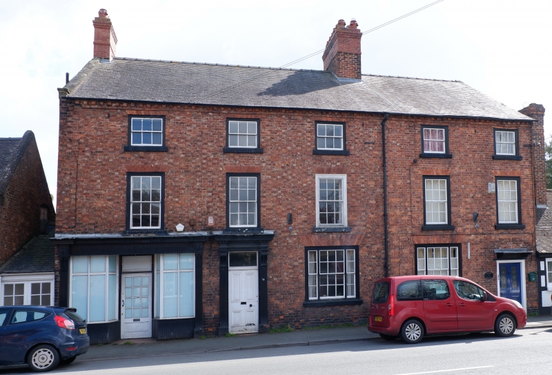
Pair of houses of c1800, incorporating a shop which was probably inserted during the C19
The present shop front retains some elements of a late C19 or early C20 design. Brick with slate roof. Three-storeys, 5-window range, originally comprising 2 dwellings of unequal size. No.17 is a
2-window range, with doorway to right, No.18 range with central entrance. Flush framed 12-pane sash windows to upper floor (9-pane to attic storey) and tripartite sashes to ground floor, all with flat arched gauged brick heads. No.17 retains its original doorway with canopy hood; insertion of shop front has modified the arrangement to the left, but the doorway alongside the shop appears to be early C19, and has case with bracketed entablature. Shop front itself has central doorway, windows divided by slim mullions and a transom, and fascia carried on brackets. Dentilled eaves band. Axial stacks, raised during the C19. Coped gable to left.
A good building of c1800, urban in character. Part of an important group of buildings on High Street.
External links are from the relevant listing authority and, where applicable, Wikidata. Wikidata IDs may be related buildings as well as this specific building. If you want to add or update a link, you will need to do so by editing the Wikidata entry.


Other nearby listed buildings
