History in Structure

Pont Marchogian

A Grade II Listed Building in Bangor, Gwynedd

More Photos »
Approximate Location Map
Large Map »

Coordinates

Latitude: 53.2281 / 53°13'41"N

Longitude: -4.1087 / 4°6'31"W

OS Eastings: 259334

OS Northings: 372189

OS Grid: SH593721

Mapcode National: GBR 5Q.0QDC

Mapcode Global: WH547.V4N4

Plus Code: 9C5Q6VHR+6G

Entry Name: Pont Marchogian

Listing Date: 2 August 1988

Last Amended: 2 August 1988

Grade: II

Source: Cadw

Source ID: 4084

Building Class: Transport

ID on this website: 300004084

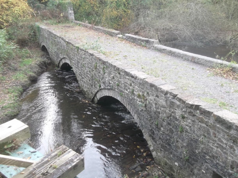
Location: Reached along the footpath (dismantled railway) below the road. Spanning the River Cegin near the Old Wharf. Wooded site below the modern Glantraeth estate; at a splayed angle to the later railway br

County: Gwynedd

Community: Llandygai (Llandygái)

Community: Llandygai

Traditional County: Caernarfonshire

Tagged with: Bridge Railway bridge

Find accommodation in
Llandegfan

History

Built before 1790/1; began as part of the old tramroad, designed by Benjamin Wyatt, running from the newly constructed Port Penrhyn up to Nant Ffrancon. Incorporated the Llandegai Tramway which was the first of its kind in North West Wales and included a balance incline. The Penrhyn railroad development out of this - opened in 1801, also by Benjamin Wyatt. This became a major tourist attraction and was ‘Wales’ first narrow gauge slate railway. The bridge has been disused since the closing of the Railroad in October 1879.

Exterior

Low and narrow coursed rubble bridge; 3 segmental arched with voussoirs and arch rings; small square headed opening at the N end. Overgrown at the time of inspection (December 1987).

External Links

External links are from the relevant listing authority and, where applicable, Wikidata. Wikidata IDs may be related buildings as well as this specific building. If you want to add or update a link, you will need to do so by editing the Wikidata entry.

Recommended Books

Other nearby listed buildings

  • II Incline Cottage
    Reached up a short farm road, on the edge of Penrhyn Park.
  • II Former Stables at Plas y Coed
    Attached to west end of house at Plas y Coed forming small U-shaped courtyard.
  • II Plas y Coed
    Located at end of drive-way running south-eastwards from the area in front of Port Lodge; tarmac area on north used for car parking; garden to south overlooks Penrhyn Park.
  • II Tan-y Bryn Lodge
    Set into the hillside at the base of the drive to Tan-y-Bryn house; at a splayed angle to the main road.
  • II Penrhyn Bridge, including parapet walls on the approach road to Penrhyn Castle Port
    Spanning the Afon Cegin at the inner end of Penrhyn Docks. Reached off the Llandegai road and carrying the rear drive into the Penrhyn Estate.
  • II Penybryn House
    Situated on a terrace above the sunken section of the old Holyhead road and reached by the lane up to the Golf Club; approached from the right past The Old Farmhouse
  • II Pont Penrhyn (partly in Bangor community)
    Spanning the Afon Cegin just south of the present main approach to the docks at Porth Penrhyn, the road carried by the bridge leads to the Port Lodge entrance to Penrhyn Castle.
  • II Parapet/Boundary Walls on Port Lodge approach to Penrhyn Castle
    Eastern continuation of abutments to Pont Penrhyn, on the north side running down the lane between the Penrhyn Estate Office and Port House and on the south side towards Port Lodge; the walls also con

BritishListedBuildings.co.uk is an independent online resource and is not associated with any government department. All government data published here is used under licence. Please do not contact BritishListedBuildings.co.uk for any queries related to any individual listed building, planning permission related to listed buildings or the listing process itself.

British Listed Buildings is a Good Stuff website.