Approximate Location Map
Large Map »
Latitude: 53.301 / 53°18'3"N
Longitude: -4.5971 / 4°35'49"W
OS Eastings: 227028
OS Northings: 381374
OS Grid: SH270813
Mapcode National: GBR HM0Z.BZF
Mapcode Global: WH42H.C946
Plus Code: 9C5Q8C23+C4
Entry Name: Tower, walls and courtyard buildings
Listing Date: 22 February 1993
Last Amended: 30 June 1998
Grade: II
Source: Cadw
Source ID: 5765
Building Class: Domestic
ID on this website: 300005765
Location: Located at the heart of the Penrhos Coastal Park at the SE end of Holy Island; reached by private driveway N of the A5(T) and c1.25km NNE of the N end of the Stanley Embankment. The tower is adjacent
County: Isle of Anglesey
Community: Holyhead (Caergybi)
Community: Holyhead
Locality: Penrhos Coastal Park
Traditional County: Anglesey
Tagged with: Courtyard
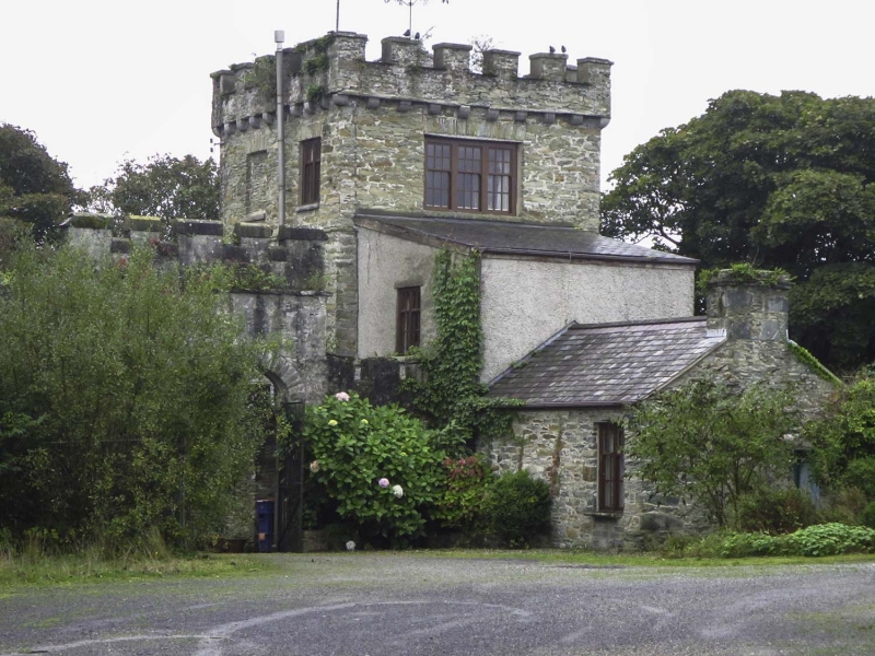
The Penrhos estate was the principal seat on Holy Island and became the home of the Stanley family in 1763. Penrhos house was completely remodelled for John Thomas Stanley in early C19. The Tower appears to form part of the service buildings associated with the mansion and is probably contemporary with the remodelling of Penrhos, c1802-8; within the tower, the dairy was altered c1900 by Henry Stanley, 3rd Baron. The Tower was being refurbished when inspected, May 1997, and some further alterations have taken place including the reinstatement of a fireplace in the dairy. Penrhos house became ruinous after 1945 and was later almost entirely demolished. The estate was bought by Anglesey Aluminium in 1969 and made into a country park in 1972. The estate buildings were being refurbished when inspected, May 1997.
An enclosed courtyard S of the remains of the Penrhos House, closed to N by a crenellated segmental arched gateway, with keystone. Right (W) of the gateway is the Tower; principally comprising a 3-storey square tower for service accommodation (also said to include Dairy, Laundry and Gun-Room), extended to N by storeyed lean-to extension (rendered) and single storey gabled wing; front (E) elevation with single-storeyed entrance range, stepped flanking turret at SE corner with subsidiary, pointed arched gateway to garden, bordered by a further crenellated wall which steps forward with small corner towers and arrowslits. Tower is of rubble construction with corbelled and crenellated parapet and band courses between floors; hipped slate roof. Voussoirs to square-headed windows with modern small-paned lights; 1-window main elevations but 2-windows facing outhouse to N; outside stairs to S roofed over. Left (E) of the main gateway is a gable ended range to the rear of the Penrhos House remains, with a Gothic timber bellcote with fishscale roof.
The entrance to the tower leads into the dairy which occupies the ground floor of the main part. The dairy retains tiled walls containing friezes of pastoral scenes; an ornate cast iron fire surround has recently been re-set in the dairy and the upstairs room has a green marble fire surround, probably also re-set recently.
Listed as a group of estate buildings forming a significant surviving element in the layout associated with the lost mansion of Penrhos, and in the striking castellated style characteristic of the Penrhos estate buildings of this period.
External links are from the relevant listing authority and, where applicable, Wikidata. Wikidata IDs may be related buildings as well as this specific building. If you want to add or update a link, you will need to do so by editing the Wikidata entry.


Other nearby listed buildings
