Approximate Location Map
Large Map »
Latitude: 51.6153 / 51°36'54"N
Longitude: -4.9392 / 4°56'21"W
OS Eastings: 196605
OS Northings: 194808
OS Grid: SR966948
Mapcode National: GBR G8.J147
Mapcode Global: VH1SD.BNPL
Plus Code: 9C3QJ386+48
Entry Name: St. Michael and All Angels' Church Cross
Listing Date: 14 May 1970
Last Amended: 8 February 1996
Grade: II
Source: Cadw
Source ID: 5928
Building Class: Religious, Ritual and Funerary
ID on this website: 300005928
County: Pembrokeshire
Community: Stackpole and Castlemartin (Stackpole a Chastellmartin)
Community: Stackpole and Castlemartin
Locality: Bosherston
Traditional County: Pembrokeshire
Tagged with: Christian cross
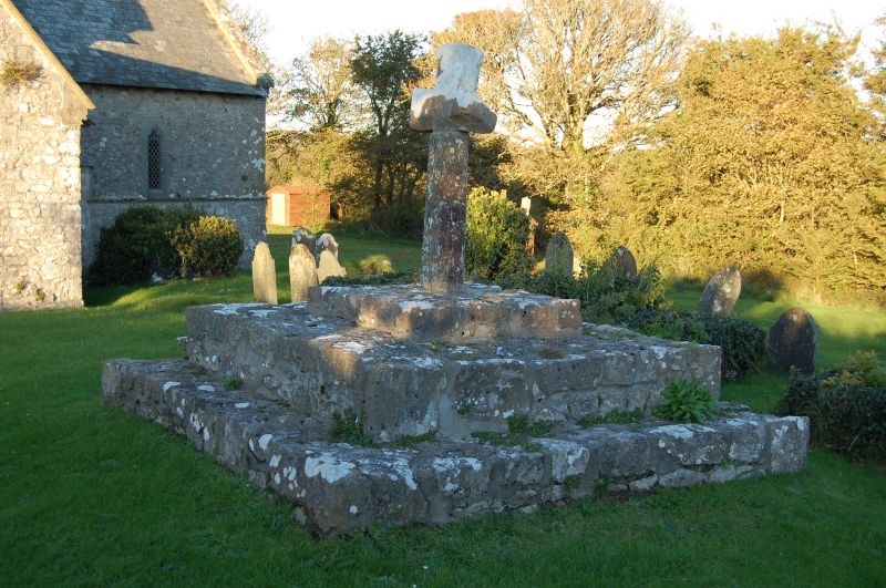
Opposite to the S door of St. Michael's church, in the churchyard.
Base of three steps in a fragmented condition, with an old cross in two sections. Plain octagonal shaft. Face of Christ carved at the intersection of the arms, on the W-facing side. Perhaps C14.
Listed for rare mediaeval carving; group value with the church.
Reference: Arch Cambr V v (1888) 124
Dyfed Arch Trust S&M PRN 628
External links are from the relevant listing authority and, where applicable, Wikidata. Wikidata IDs may be related buildings as well as this specific building. If you want to add or update a link, you will need to do so by editing the Wikidata entry.


Other nearby listed buildings
