History in Structure

Gate Piers at former Railway Crossing

A Grade II Listed Building in Aberdare, Rhondda Cynon Taff

More Photos »
Approximate Location Map
Large Map »

Coordinates

Latitude: 51.7235 / 51°43'24"N

Longitude: -3.4653 / 3°27'55"W

OS Eastings: 298884

OS Northings: 203764

OS Grid: SN988037

Mapcode National: GBR HK.2M2F

Mapcode Global: VH5GF.WYD5

Plus Code: 9C3RPGFM+9V

Entry Name: Gate Piers at former Railway Crossing

Listing Date: 10 January 1991

Last Amended: 10 January 1991

Grade: II

Source: Cadw

Source ID: 10880

Building Class: Transport

ID on this website: 300010880

Location: At the northern edge of Trecynon; beside the road at the 'S' bend.

County: Rhondda Cynon Taff

Community: Aberdare (Aberdâr)

Community: Aberdare West

Locality: Trecynon

Built-Up Area: Aberdare

Traditional County: Glamorgan

Tagged with: Gatepost

Find accommodation in
Aberdare

History

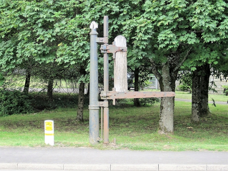
At this point the Great Western Railway (Aman Branch) crossed the road out of Trecynon to Cwmdare and Hirwaun. However these gate posts are placed too far apart for the single track railway that existed. Either the smaller of the two piers has been moved E or more likely it was infact a pier for a pedestrian gate at the side of the track.

Exterior

The left hand gate post is a complex assembly of cast iron and wood. Tapered cast iron column stamped GWR T47 with finial and spurs linking with thin square pole hinged to a massive timber post thickened to top with inverted spandrel stamped T116 between this and the arm that formerly attached to the gate; quatrefoil ornament. The plain square iron pier to right was probably a locking post for a pedestrian gate; pyramidal cap.

External Links

External links are from the relevant listing authority and, where applicable, Wikidata. Wikidata IDs may be related buildings as well as this specific building. If you want to add or update a link, you will need to do so by editing the Wikidata entry.

Recommended Books

Other nearby listed buildings

  • II Gates 7 Gate Piers, including Flanking Railings, at NW Entrance to Aberdare Park
    Closing the NW drive entrance to the park immediately SW of the junction with Cemetery Road.
  • II St. Fagan's Church
    Reached by lane from the street and tree lined path. Set at the northern end of a sloping, walled, churchyard. Vicarage immediately to NE.
  • II Vicarage to St Fagan's Church
    Immediately to NE of the Church, slightly stepped down. Reached up a lane from the street; also direct from the churchyard.
  • II Carmel (Bryn Sion) Chapel
    On sloping site at a splayed angle to the road flanked by Mount Pleasant Street and Margaret Street and facing down Llewellyn Street. Railed forecourt.
  • II Capel Ebenezer
    Set back at a splayed angle to the road behind grassed and tiled forecourt.
  • II Hall attached to Capel Y Bedyddwyr
    Built in l852 to the design of Thomas Joseph, local coal owner and engineer; cost ú920. Became a self-governing church in l855 and then in l893 was extensively remodelled. In l904 further alteration
  • II Llwydcoed Tramroad Bridge
    Spans the River Cynon at the boundary between the Communities of Aberdare and Llwydcoed. Reached by a lane from the roundabout to SE, past the factory; in the area known as Gelli-Isaf. Steep wooded
  • II Heol Y Felin (Capel Y Bedyddwyr)
    Above the road and set back behind forecourt including small burial ground.

BritishListedBuildings.co.uk is an independent online resource and is not associated with any government department. All government data published here is used under licence. Please do not contact BritishListedBuildings.co.uk for any queries related to any individual listed building, planning permission related to listed buildings or the listing process itself.

British Listed Buildings is a Good Stuff website.