History in Structure

Gates 7 Gate Piers, including Flanking Railings, at NW Entrance to Aberdare Park

A Grade II Listed Building in Aberdare, Rhondda Cynon Taff

More Photos »
Approximate Location Map
Large Map »

Coordinates

Latitude: 51.7218 / 51°43'18"N

Longitude: -3.4604 / 3°27'37"W

OS Eastings: 299218

OS Northings: 203568

OS Grid: SN992035

Mapcode National: GBR HK.2N9M

Mapcode Global: VH5GF.YZZH

Plus Code: 9C3RPGCQ+PR

Entry Name: Gates 7 Gate Piers, including Flanking Railings, at NW Entrance to Aberdare Park

Listing Date: 10 January 1991

Last Amended: 10 January 1991

Grade: II

Source: Cadw

Source ID: 10889

Building Class: Domestic

ID on this website: 300010889

Location: Closing the NW drive entrance to the park immediately SW of the junction with Cemetery Road.

County: Rhondda Cynon Taff

Community: Aberdare (Aberdâr)

Community: Aberdare West

Locality: Trecynon

Built-Up Area: Aberdare

Traditional County: Glamorgan

Tagged with: Gate Railing Gatepost

Find accommodation in
Aberdare

History

Aberdare Park was laid out on a part of Hirwaun Common on the instigation of R H Rhys, Chairman of the Local Board of Health "as a pleasant place for the dust begrimed inhabitants". Opened on 27tháJulyál869 and walled in 1877. These are not the original gates and piers but were erected after the War.

Exterior

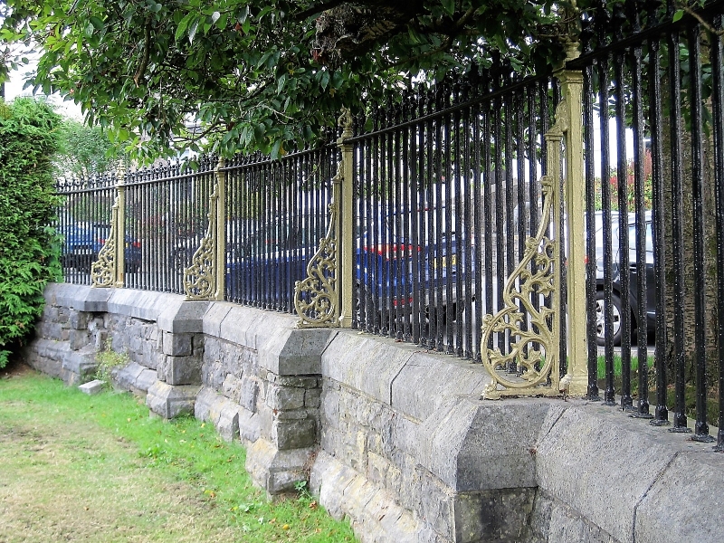
2 tall stone square piers with pyramidical caps. The carriage and pedestrian iron gates all have simple panels and lock bars; the main carriage gates also have scrolled ironwork to the top. Low rubble walls to either side curving back to ends terminating im similar square piers; finialled iron railings with more elaborate principal uprights which have scrolled brackets to the inner side.

Reasons for Listing

Included for group value with other listed items in Aberdare Park.

External Links

External links are from the relevant listing authority and, where applicable, Wikidata. Wikidata IDs may be related buildings as well as this specific building. If you want to add or update a link, you will need to do so by editing the Wikidata entry.

Recommended Books

Other nearby listed buildings

  • II Carmel (Bryn Sion) Chapel
    On sloping site at a splayed angle to the road flanked by Mount Pleasant Street and Margaret Street and facing down Llewellyn Street. Railed forecourt.
  • II St. Fagan's Church
    Reached by lane from the street and tree lined path. Set at the northern end of a sloping, walled, churchyard. Vicarage immediately to NE.
  • II Capel Ebenezer
    Set back at a splayed angle to the road behind grassed and tiled forecourt.
  • II Vicarage to St Fagan's Church
    Immediately to NE of the Church, slightly stepped down. Reached up a lane from the street; also direct from the churchyard.
  • II Hall attached to Capel Y Bedyddwyr
    Built in l852 to the design of Thomas Joseph, local coal owner and engineer; cost ú920. Became a self-governing church in l855 and then in l893 was extensively remodelled. In l904 further alteration
  • II Heol Y Felin (Capel Y Bedyddwyr)
    Above the road and set back behind forecourt including small burial ground.
  • II Hen Dy Cwrdd Chapel
    Set back from the road at the junction with Mount Pleasant Street. Walled burial ground to the front.
  • II 37 & 37a Alma Street
    Detached near the top of the street.

BritishListedBuildings.co.uk is an independent online resource and is not associated with any government department. All government data published here is used under licence. Please do not contact BritishListedBuildings.co.uk for any queries related to any individual listed building, planning permission related to listed buildings or the listing process itself.

British Listed Buildings is a Good Stuff website.