History in Structure

Tramroad Bridge

A Grade II Listed Building in Aberdare, Rhondda Cynon Taff

More Photos »
Approximate Location Map
Large Map »

Coordinates

Latitude: 51.7224 / 51°43'20"N

Longitude: -3.4533 / 3°27'11"W

OS Eastings: 299712

OS Northings: 203631

OS Grid: SN997036

Mapcode National: GBR HK.2Q2T

Mapcode Global: VH6CX.3Y7Z

Plus Code: 9C3RPGCW+XM

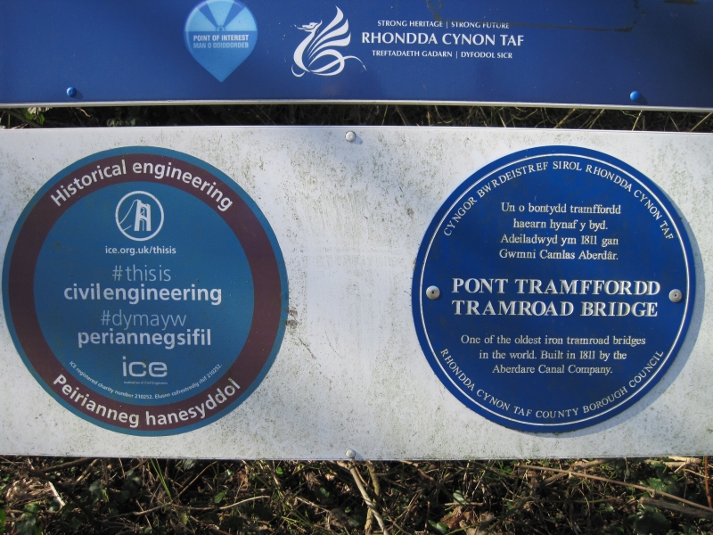
Entry Name: Tramroad Bridge

Listing Date: 10 January 1991

Last Amended: 10 January 1991

Grade: II

Source: Cadw

Source ID: 10894

Building Class: Transport

Also known as: Tramroad Bridge,Trecynon

ID on this website: 300010894

Location: Spanning the River Cynon immediately below the modern A4059 bypass.

County: Rhondda Cynon Taff

Community: Aberdare (Aberdâr)

Community: Aberdare West

Locality: Trecynon

Built-Up Area: Aberdare

Traditional County: Glamorgan

Tagged with: Bridge Tram bridge

Find accommodation in
Aberdare

History

Erected in l811 and manufactured by the Abernant Foundry. Carried the tramroad from Abernant across to the Trecynon area; may also have carried traffic for Ysguborwen and Aberdare works.

Exterior

Early cast-iron bridge ca 3m wide and ca l0.5m long; rubble abutments. Decking of cast iron plates on four arched lattice beams. Simple modern iron parapets, one upright is reused and inscribed 'Abernant l8ll'. Ridged top to the deck providing the horses with grip when pulling across the bridge. Abutments are slightly curved outwards at ends. Recently restored and now forming part of a public footpath.

Scheduled Ancient Monument: Gm347

External Links

External links are from the relevant listing authority and, where applicable, Wikidata. Wikidata IDs may be related buildings as well as this specific building. If you want to add or update a link, you will need to do so by editing the Wikidata entry.

Recommended Books

Other nearby listed buildings

  • II 37 & 37a Alma Street
    Detached near the top of the street.
  • II Hen Dy Cwrdd Chapel
    Set back from the road at the junction with Mount Pleasant Street. Walled burial ground to the front.
  • II Heol Y Felin (Capel Y Bedyddwyr)
    Above the road and set back behind forecourt including small burial ground.
  • II Hall attached to Capel Y Bedyddwyr
    Built in l852 to the design of Thomas Joseph, local coal owner and engineer; cost ú920. Became a self-governing church in l855 and then in l893 was extensively remodelled. In l904 further alteration
  • II Capel Ebenezer
    Set back at a splayed angle to the road behind grassed and tiled forecourt.
  • II Carmel (Bryn Sion) Chapel
    On sloping site at a splayed angle to the road flanked by Mount Pleasant Street and Margaret Street and facing down Llewellyn Street. Railed forecourt.
  • II Vicarage to St Fagan's Church
    Immediately to NE of the Church, slightly stepped down. Reached up a lane from the street; also direct from the churchyard.
  • II St. Fagan's Church
    Reached by lane from the street and tree lined path. Set at the northern end of a sloping, walled, churchyard. Vicarage immediately to NE.

BritishListedBuildings.co.uk is an independent online resource and is not associated with any government department. All government data published here is used under licence. Please do not contact BritishListedBuildings.co.uk for any queries related to any individual listed building, planning permission related to listed buildings or the listing process itself.

British Listed Buildings is a Good Stuff website.