Approximate Location Map
Large Map »
Latitude: 51.4842 / 51°29'2"N
Longitude: -3.6814 / 3°40'53"W
OS Eastings: 283342
OS Northings: 177475
OS Grid: SS833774
Mapcode National: GBR H8.KLQS
Mapcode Global: VH5HH.4YMM
Plus Code: 9C3RF8M9+MC
Entry Name: 22, Newton Nottage Road, Newton, Porthcawl, MID GLAMORGAN, CF36 5PF
Listing Date: 13 March 1989
Last Amended: 17 February 1998
Grade: II
Source: Cadw
Source ID: 11357
Building Class: Domestic
ID on this website: 300011357
Location: At the W end of the old village, set back from the road behind rubble walled front garden, detached to right; almost opposite Tudor Cottage, also listed.
County: Bridgend
Town: Porthcawl
Community: Porthcawl
Community: Porthcawl
Locality: Newton
Built-Up Area: Porthcawl
Traditional County: Glamorgan
Tagged with: Building
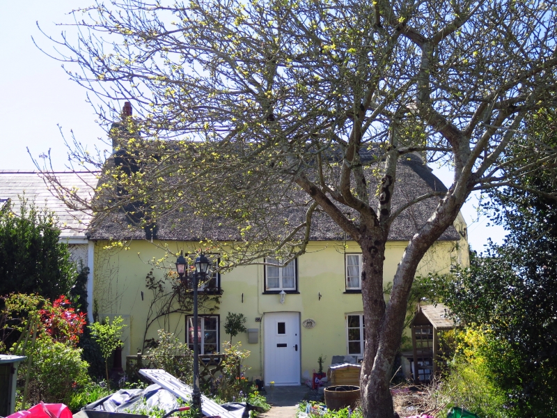
Probably c 1700. Original plan of two units with direct entry, front eaves probably raised when new windows installed late C19/early C20 though level unaltered; replaced timber roof structure. Bordering old road linking the two medieval settlements of Newton and Nottage.
Built of stone rendered and painted; thatched roof with simply ornamented ridge and undulating eaves and pebble dashed end stacks. Two storeys 3 window range of 3/3 pane casements, cambered lintels to ground floor and small window to end right; central doorway with cambered lintel and replacement door. Shallow masonry projection to left and splayed corner to right adjacent to semi-cicular projection on gable end containing the base of the winding stone stairs. Extension to rear.
No access to interior but previous list description records house has central cross passage following insertion of dividing wall to right, originally entered directly into hall to right. This retains lightly chamfered cambered lintel to fireplace with bread oven; to left stairs formerly entered by boarded door across angle; to left of that on former rear wall is blocked doorway possibly to former cross wing or outshut; on front wall is a recess lit by small window. On left of main entrance is former heated outer room now dining room. At rear of passage is 4 centred chamfered arched dressed stone doorway. Roof timbers exposed on upper floor.
Included although altered as a survival of a regional house type with roof of thatch, formerly a more common building material in this area, and for group value with Tudor Cottage almost opposite.
External links are from the relevant listing authority and, where applicable, Wikidata. Wikidata IDs may be related buildings as well as this specific building. If you want to add or update a link, you will need to do so by editing the Wikidata entry.


Other nearby listed buildings
