Approximate Location Map
Large Map »
Latitude: 51.5886 / 51°35'19"N
Longitude: -3.0133 / 3°0'47"W
OS Eastings: 329896
OS Northings: 188241
OS Grid: ST298882
Mapcode National: GBR J5.C0RS
Mapcode Global: VH7BC.QBCH
Plus Code: 9C3RHXQP+FM
Entry Name: 18, Fields Park Avenue, Allt-yr-yn, GWENT
Listing Date: 20 December 1994
Last Amended: 14 September 1999
Grade: II
Source: Cadw
Source ID: 15671
Building Class: Domestic
ID on this website: 300015671
Location: Prominently located on the S side of Fields Park Avenue, approximately midway along.
County: Newport
Community: Allt-yr-yn (Allt-yr-ynn)
Community: Allt-yr-Yn
Locality: Allt-yr-yn
Built-Up Area: Newport
Traditional County: Monmouthshire
Tagged with: Building
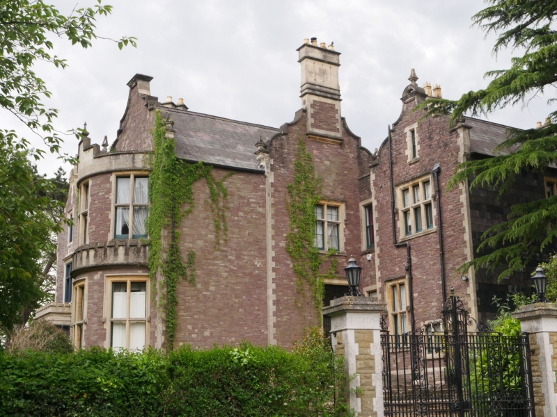
Built as a large private house, c1870-80, and probably designed by Habershon and Faulkner, architects, of Newport.
One of a pair with no 62 Fields Park Road, in a 'Jacobethan' style. Random square red sandstone rubble, with freestone dressings and some slate hanging; slate roofs, with gable end and axial stacks. 2 storeyed, with principal rooms facing E and W. Entrance in N elevation of E range, in angle with the longer W range (which included service rooms). Rear elevation (facing W) comprises 3 parallel Dutch gables: right hand gable houses principal rooms and has a full-height canted bay window with plain chamfered mullioned and transomed sashes on each floor. 2 left hand gables house service rooms etc: 3-light mullioned and transomed window to ground floor of central gable, with oriel window above. Lean-to addition across lower floor of left hand gable which has window with drop-ended hood-mould in its N-facing return. Dutch gable facing E, with blocked pointed arched doorway, and windows with drop-ended hood-moulds. Entrance in N wall of E range: recessed porch, with drop-ended hood-moulds to architrave of outer doorway. 2-light mullioned and transomed window above, and stack corbelled out from the apex of the shaped gable. Garden front faces E: Dutch gable to right, with full-height bow window, with 3x2-light mullioned and transomed sash windows which have drop-ended hood-moulds to ground floor. Castellated 'apron' above the first floor windows. Parallel narrower gable alongside it to the S, with mullioned and transomed windows of 2- and 3-lights with hood-moulds on each floor. The moulded entablature of the lower window serves to slightly corbel out the upper part of the gable.
Central, internal stairhall with dado panelling and fireplace retaining original chimney piece. Open-well staircase, top lit by a shallow dome with painted glass, timber supporting ribs and central pendant. Principal rooms retain original fittings in a C18 style, including fireplaces, plaster cornices, and window shutters. Raised mouldings to wall panels (for fabric or paper) in drawing room, and oak panelling in small sitting room. Wainscot panelling in W-facing dining room, with reeded pilasters.
A very good example of the Jacobethan style favoured in the later C19 for large suburban houses, which includes an exceptionally fine interior.
External links are from the relevant listing authority and, where applicable, Wikidata. Wikidata IDs may be related buildings as well as this specific building. If you want to add or update a link, you will need to do so by editing the Wikidata entry.


Other nearby listed buildings
