Approximate Location Map
Large Map »
Latitude: 52.9867 / 52°59'11"N
Longitude: -3.0387 / 3°2'19"W
OS Eastings: 330363
OS Northings: 343762
OS Grid: SJ303437
Mapcode National: GBR 74.HSFG
Mapcode Global: WH89B.9676
Plus Code: 9C4RXXP6+MG
Entry Name: No 2, Park Street (N Side) Ruabon, Clwyd
Listing Date: 22 February 1995
Last Amended: 22 February 1995
Grade: II
Source: Cadw
Source ID: 15697
Building Class: Domestic
ID on this website: 300015697
Location: Situated to the E of the Wynnstay Arms.
County: Wrexham
Community: Ruabon (Rhiwabon)
Community: Ruabon
Built-Up Area: Ruabon
Traditional County: Denbighshire
Tagged with: Building
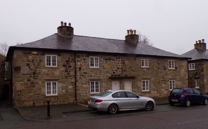
One of four blocks of estate cottages on Park Street, probably built c1840. Each block originally consisted of two 1-up 1-down units reached from the side, two 2-up, 2-down units reached from a pair of doors in the street elevation, and a further pair of 1-up 1-down units reached from the other side. All rooms had corner fireplaces and the units shared flues leading to large octagonal chimneys. Neighbouring 1-up 1-down units have now been altered to form one dwelling and the blocks all have later extensions to the rear.
Nos 1 and 2 merged.
Symmetrical elevation, 2-storey, 4 windows. Roughlycoursed and squared sandstone rubble with dressed stone quoins, hipped slate roof with two octagonal stone chimneys, that to the left rendered. Paired central entrances share a stone canopy, altered doors. Windows have hoodmoulds, those at ground floor badly eroded, those at upper level restored. Left hand return has paired entrances under shared stone canopy, that to the right now a window. Right hand return as left hand return.
Generally the two unit cottages retain basic plan from, some original stairs and blocked corner fireplaces.
Listed as part of an important group of buildings on Park Street and as fairly intact examples of carefully planned estate cottages relating to the Wynnstay Estate.
External links are from the relevant listing authority and, where applicable, Wikidata. Wikidata IDs may be related buildings as well as this specific building. If you want to add or update a link, you will need to do so by editing the Wikidata entry.


Other nearby listed buildings
