Approximate Location Map
Large Map »
Latitude: 51.83 / 51°49'47"N
Longitude: -2.7535 / 2°45'12"W
OS Eastings: 348170
OS Northings: 214862
OS Grid: SO481148
Mapcode National: GBR FJ.VX75
Mapcode Global: VH86T.785H
Plus Code: 9C3VR6HW+XH
Entry Name: Church of St Cenhedlon (aka Rockfield Church)
Listing Date: 27 November 1953
Last Amended: 19 March 2001
Grade: II
Source: Cadw
Source ID: 17423
Building Class: Religious, Ritual and Funerary
Also known as: St Cenedlon's Church, Rockfield
Rockfield Church
Church of St Cenhedlon
St Cenhedlon's Church
ID on this website: 300017423
Location: Near the centre of Rockfield village, in a wooded hollow where the road skirts the edge of a westward meander of the River Monnow.
County: Monmouthshire
Town: Monmouth
Community: Llangattock-Vibon-Avel (Llangatwg Feibion Afel)
Community: Whitecastle
Locality: Rockfield
Traditional County: Monmouthshire
Tagged with: Church building
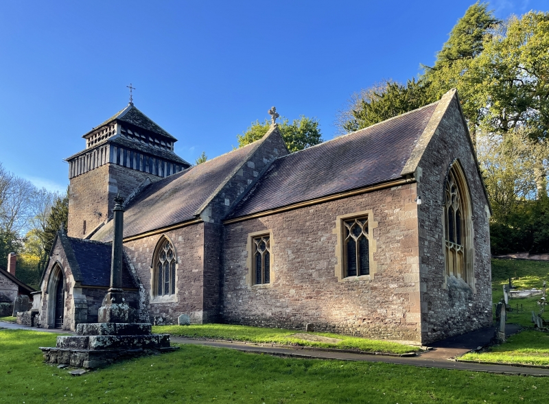
On the site of a medieval church of which only the tower survives, the rest, long in disrepair, extensively rebuilt in 1858-60 to designs of J.P.Seddon; though there appear to be traces of medieval masonry in the S wall of the chancel.
A small church with a C14 W tower, and nave, N aisle and chancel rebuilt in an effective Decorated style in 1858 by the diocesan architects Pritchard and Seddon, who restored the tower at the same time. This, like those at Skenfrith and St Maughans, is of a type characteristic of the Welsh borders, built of sandstone rubble, square on plan and sheer-walled, with a low 2-stage timber-framed "dovecote" belfry, the lower stage close-studded and the upper with 2 tiers of small square louvred openings and a pyramidal roof. It has small loop-light in each side and a Victorian 3-light traceried W window. The rest is also built of sandstone, the S side of the nave mostly snecked but otherwise random, with yellow freestone dressings and red tiled roofs. The nave, 3 bays in length, has a gabled porch in the centre of the S wall, with a moulded cusped arch, a banded extrados and a gable coping with an apex cross; a 2-light window to the L and a larger 3-light window to the R, both with reticulated tracery. The chancel, slightly lower and of 2 bays, has 2 square-headed windows with reticulated tracery, and a large 3-light E window with flowing tracery. Both nave and chancel have gable coping with an apex cross. On the N side the aisle, roofed as a continuous lean-to of the nave, has three simple 2-light windows with ogee-headed lights, and in the angle with chancel is a lean-to vestry.
The nave has a 3-bay N arcade of cylindrical columns with stiff-leaf capitals carrying chamfered and moulded 2-centred arches, and an arch-braced collar-truss roof with 2 tiers of wind-braced purlins. The chancel has a wide depressed 2-centred arch containing a very delicate wrought-iron screen (given by the Rev. John Taylor, vicar in 1875), a 3-bay roof with arch-braced collar trusses, a panelled reredos to the altar and an organ in an arch on the N side. At the E end of the N aisle are the Royal Arms of William III (discovered in use as a noticeboard at Rockfield School and restored to this position in 1976). On the S wall of the nave, to the E of the doorway, is a wall monument to John Allan Rolls, 1837-1912, 1st Baron Llangattock.
First listed for its medieval tower and now included also for the quality of the 1858 rebuild, an expressively planned and well detailed essay in Gothic Revival, with a good interior.
External links are from the relevant listing authority and, where applicable, Wikidata. Wikidata IDs may be related buildings as well as this specific building. If you want to add or update a link, you will need to do so by editing the Wikidata entry.


Other nearby listed buildings
