History in Structure

Chest tomb in the graveyard of the Church of St Mary Magdalen, Pyle with Kenfig.

A Grade II Listed Building in Cynffig, Bridgend

More Photos »
Approximate Location Map
Large Map »

Coordinates

Latitude: 51.5238 / 51°31'25"N

Longitude: -3.7218 / 3°43'18"W

OS Eastings: 280641

OS Northings: 181951

OS Grid: SS806819

Mapcode National: GBR H6.H8JM

Mapcode Global: VH5H8.FYRQ

Plus Code: 9C3RG7FH+G7

Entry Name: Chest tomb in the graveyard of the Church of St Mary Magdalen, Pyle with Kenfig.

Listing Date: 2 January 1998

Last Amended: 2 January 1998

Grade: II

Source: Cadw

Source ID: 19175

Building Class: Religious, Ritual and Funerary

ID on this website: 300019175

Location: Maudlam hamlet stands on elevated ground NE of the former borough of Kenfig. The tomb stands on the N side of the axial path leading to the W porch of the church, and 5m W of the porch.

County: Bridgend

Town: Cynffig

Community: Cornelly (Corneli)

Community: Cornelly

Locality: Maudlam

Built-Up Area: Pyle

Traditional County: Glamorgan

Tagged with: Tomb

Find accommodation in
North Cornelly

History

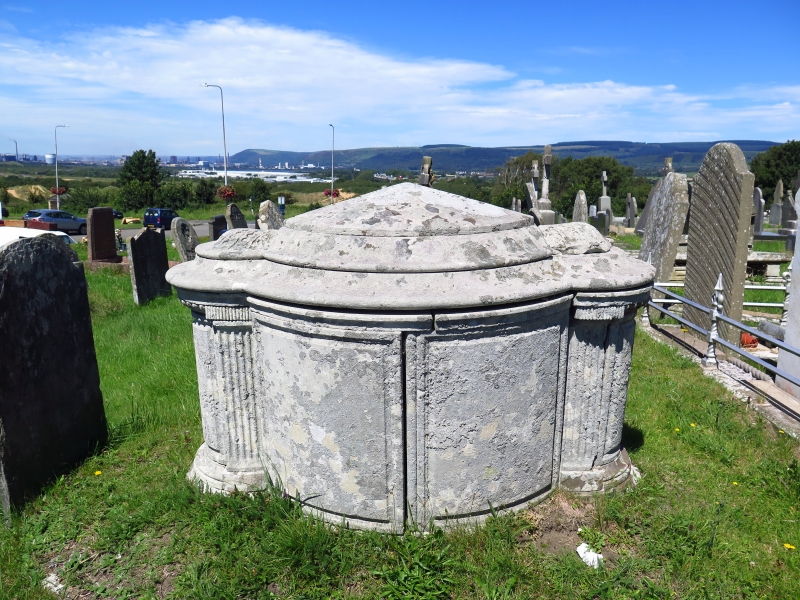
Probably late C18 or early C19.

Exterior

The chest tomb is of limestone, oval on plan, with rounded extensions at each end. The convex sides have fielded panelling, and a further panel at each end beyond fluted pilasters at the springing of the extensions. The top has two wide ogee mouldings, and rises to a central peak. Carved acanthus or vine leaves cap the end extensions. Inscriptions lightly cut on the side panels are now almost illegible. The tomb was originally enclosed by iron railings.

Reasons for Listing

Included at Grade II as a churchyard tomb of very unusual and inspired design.

External Links

External links are from the relevant listing authority and, where applicable, Wikidata. Wikidata IDs may be related buildings as well as this specific building. If you want to add or update a link, you will need to do so by editing the Wikidata entry.

Recommended Books

Other nearby listed buildings

  • II* Church of St Mary Magdalen, Pyle with Kenfig.
    The church stands in a raised curvilinear churchyard on a high prominence above the former site of Kenfig, by the junction of the side road into Maudlam village.
  • II Prince of Wales Inn, also known as Ty Newydd
    The former borough of Kenfig lies W of North Cornelly, on the edge of the sand dunes. The inn stands facing S, with the gable end against the road from Maudlam to Porthcawl.
  • II Pool Farmhouse
    Pool Farm lies towards the N end of Kenfig, lying back from the N-S road and facing W.
  • II River Black Underbridge
    Over the Afon Cynffig, accessed via a footpath from Plwerin to Llanmihangel. (Partly in Cynffig Community, Bridgend)
  • II Mill Bridge Underbridge
    Over the Afon Cynffig, down river from Llanmihangel Mill Farm. (Partly in the Cynffig Community, Bridgend).
  • II Marlas House
    The farm stands on the S bank of the Afon Cynffig, close to the railway bridge and the road from North Cornelly to Kenfig, which runs alongside the N side of the N wing.
  • II Morfa Bach Access Underbridge (East)
    Accessed from an unclassified road to the south of Kenfig Industrial Estate.
  • II* Llanmihangel
    Located at the end of a track which runs N off Marlas Road, Pyle. N of Llanmihangel Mill Farm.

BritishListedBuildings.co.uk is an independent online resource and is not associated with any government department. All government data published here is used under licence. Please do not contact BritishListedBuildings.co.uk for any queries related to any individual listed building, planning permission related to listed buildings or the listing process itself.

British Listed Buildings is a Good Stuff website.