Approximate Location Map
Large Map »
Latitude: 53.2214 / 53°13'16"N
Longitude: -4.2084 / 4°12'30"W
OS Eastings: 252655
OS Northings: 371646
OS Grid: SH526716
Mapcode National: GBR 5L.145S
Mapcode Global: WH546.B978
Plus Code: 9C5Q6QCR+HJ
Entry Name: Telford Milestone
Listing Date: 21 April 1998
Last Amended: 17 June 2020
Grade: II
Source: Cadw
Source ID: 19661
Building Class: Transport
ID on this website: 300019661
Location: In the centre of Llanfairpwll, set into the wall outside Ty Coch, on the N side of Holyhead Road, opposite Ty Gwyn Public House.
County: Isle of Anglesey
Community: Llanfair Pwllgwyngyll
Community: Llanfair Pwllgwyngyll
Locality: Llanfairpwllgwyngyll
Built-Up Area: Llanfair Pwllgwyngyll
Tagged with: Milestone
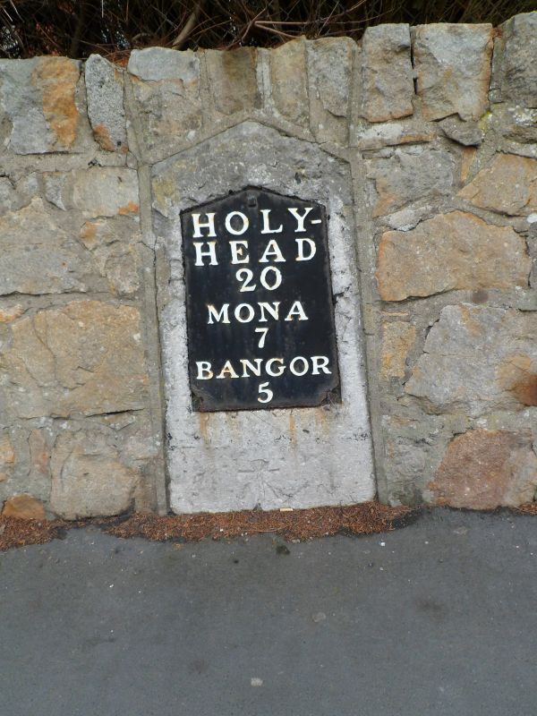
Following the Act of Union in 1801 a programme to improve the roads between the two capital cities of London and Dublin was initiated. In 1811 Thomas Telford was commissioned to undertake a survey of the roads between London and Holyhead and in 1817 began work on the northern stretch of the road at Shrewsbury. As well as overseeing the work, Thomas Telford also designed every detail of the road, and this milestone is one of a number designed for it. The completion of the stage between Holyhead and Menai Bridge saw all the milestones across Anglesey and into Bangor erected between 1825 and February 1826.
Dressed Anglesey limestone slab, with shallow triangular head and raking chamfered sides. Cast iron inset plate white lettering on black reading: HOLY- / HEAD / 20 / MONA / 7 / BANGOR / 5.
Listed as a fine example of one of Telford's milestones retaining its cast iron plate.
External links are from the relevant listing authority and, where applicable, Wikidata. Wikidata IDs may be related buildings as well as this specific building. If you want to add or update a link, you will need to do so by editing the Wikidata entry.


Other nearby listed buildings
