Approximate Location Map
Large Map »
Latitude: 53.2925 / 53°17'33"N
Longitude: -4.5888 / 4°35'19"W
OS Eastings: 227551
OS Northings: 380409
OS Grid: SH275804
Mapcode National: GBR HN10.2SB
Mapcode Global: WH42H.HH3R
Plus Code: 9C5Q7CV6+2F
Entry Name: Stanley Tollhouse
Listing Date: 1 August 1952
Last Amended: 30 June 1998
Grade: II
Source: Cadw
Source ID: 20069
Building Class: Transport
ID on this website: 300020069
Location: Set back from the N side of the A5(T), directly over the northern end of the Stanley Embankment and within Penrhos Coastal Park.
County: Isle of Anglesey
Community: Holyhead (Caergybi)
Community: Holyhead
Locality: Penrhos Coastal Park
Traditional County: Anglesey
Tagged with: Tollhouse
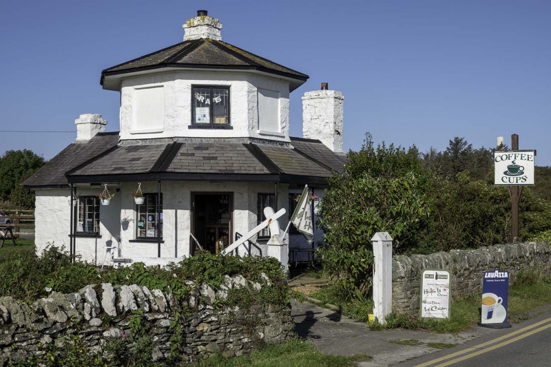
Following the Act of Union in 1801 a programme to improve the roads between the two capital cities of London and Dublin was initiated. In 1811 Thomas Telford was commissioned to undertake a survey of the roads between London and Holyhead and in 1817 began work on the northern stretch of the road at Shrewsbury. Work started on Anglesey in 1818 and 5 tollhouses, designed by Telford, were built across the island. In 1844 a law was passed abolishing tolls from Holyhead to Shrewsbury but an exemption was made of the tollhouses of Anglesey where charges were actually increased and proved adequate for the maintenance of the roads for several years. In 1895 the exemption ended and on 28th November the tollhouses were sold. Stanley tollhouse stands in the grounds of the Penrhos estate, the principal seat on Holy Island and home of the Stanley family; the estate was bought by Anglesey Aluminium in 1969 and made into a country park in 1972. In 1974 the tollhouse was moved stone by stone from the edge of the A5 to its present location; it now houses a cafeteria.
Octagonal 2-storey toll house forming a symmetrical composition with single storey wings to N and W. Stone walls roughcast and whitewashed, slate roof with projecting eaves. Central stack to octagon with gable stacks to each wing. Slate roofed verandah supported on 7 cast iron posts. Windows are slightly recessed 3-light casements; each face of the upper storey has window-sized recesses, the SE face above the door, with a 2-light casement, the others blank.
Included as an example of one of Telford's toll houses, an elegant design, retaining much of the original architectural interest, notwithstanding its removal from its original site and consequent loss of its original historic context.
External links are from the relevant listing authority and, where applicable, Wikidata. Wikidata IDs may be related buildings as well as this specific building. If you want to add or update a link, you will need to do so by editing the Wikidata entry.


Other nearby listed buildings
