History in Structure

Ffynnon y Wrach

A Grade II Listed Building in Trearddur, Isle of Anglesey

More Photos »
Approximate Location Map
Large Map »

Coordinates

Latitude: 53.3075 / 53°18'26"N

Longitude: -4.6681 / 4°40'5"W

OS Eastings: 222327

OS Northings: 382265

OS Grid: SH223822

Mapcode National: GBR GMVY.VW9

Mapcode Global: WH31B.84B8

Plus Code: 9C5Q884J+XQ

Entry Name: Ffynnon y Wrach

Listing Date: 30 June 1998

Last Amended: 30 June 1998

Grade: II

Source: Cadw

Source ID: 20077

Building Class: Water Supply and Drainage

ID on this website: 300020077

Location: Set back slightly from the SE side of the road below Holyhead mountain, SW of Holyhead.

County: Isle of Anglesey

Community: Trearddur

Community: Trearddur

Locality: North Stack

Traditional County: Anglesey

Tagged with: Architectural structure

Find accommodation in
South Stack

History

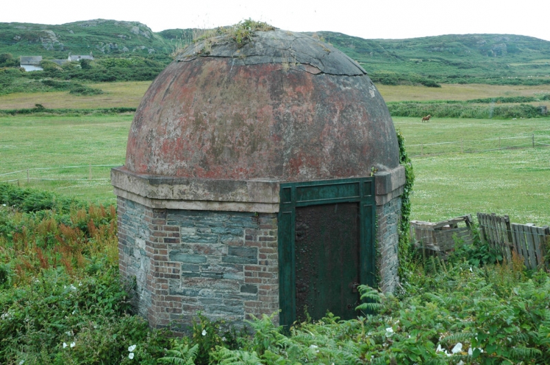
One of the 6 'Holy Wells' on Holy Island, Ffynnon y Wrach was often used as a source of water for residents of Holyhead. Well housing probably late C19 or early C20.

Exterior

An octagonal well building with domed roof. Walls of rubble with brick angle quoins, plinth of similar materials and rendered stepped cornice under a cement rendered concrete domed roof. The cornice is broken by the cast iron lintel and jambs of the single doorway in the NW face; each with recessed panels with stressed surrounds.

Reasons for Listing

Listed as a late C19 well house, of highly unusual design and construction.

External Links

External links are from the relevant listing authority and, where applicable, Wikidata. Wikidata IDs may be related buildings as well as this specific building. If you want to add or update a link, you will need to do so by editing the Wikidata entry.

Recommended Books

Other nearby listed buildings

  • II Cottage on corner of Pentre Pella (including Foregardem Wall)
    In settlement on lower slopes of Holyhead Mountain, above south stack road. On S corner of Pentre Pella, at R of row, facing SE.
  • II Tan-y-Cytiau
    In an elevated position on the slopes of Holyhead Mountain, approached from the lane that leads to South Stack Lighthouse.
  • II Gunpowder Magazine
    To N of road to Breakwater Country Park, approximately 200m W of bridge over road.
  • II Porthyfelin House
    Approximately 200m NW of junction of Porth-y-Felin Road and Beach Road with main front facing E (away from road).
  • II Soldier's Point House
    Close to landward end of great breakwater. In extensive grounds which include garden walls and ornaments in similar style to grand screen wall to N of house.
  • II Screen Wall to Soldier's Point House
    To N and NW of Soldier’s Point House.

BritishListedBuildings.co.uk is an independent online resource and is not associated with any government department. All government data published here is used under licence. Please do not contact BritishListedBuildings.co.uk for any queries related to any individual listed building, planning permission related to listed buildings or the listing process itself.

British Listed Buildings is a Good Stuff website.