Approximate Location Map
Large Map »
Latitude: 51.7006 / 51°42'1"N
Longitude: -2.7113 / 2°42'40"W
OS Eastings: 350936
OS Northings: 200440
OS Grid: SO509004
Mapcode National: GBR JK.44P6
Mapcode Global: VH87D.YJH6
Plus Code: 9C3VP72Q+6F
Entry Name: Beaufort Pond Dam
Listing Date: 29 September 2000
Last Amended: 9 October 2001
Grade: II
Source: Cadw
Source ID: 24054
Building Class: Water Supply and Drainage
ID on this website: 300024054
Location: About 500m above Old Furnace with the Trellech road crossing the dam crest.
County: Monmouthshire
Town: Chepstow
Community: Tintern (Tyndyrn)
Community: Wye Valley
Locality: Pont-y-saeson
Traditional County: Monmouthshire
Tagged with: Dam
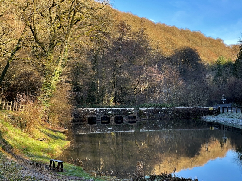
The dam was built to provide power to the bellows of the blast furnace, the remains of which are displayed about 500m downstream. The present structure is probably mostly C18 with some reconstruction in the C19 and the early C20, but the dam may originate in the C16 when the blast furnace first opened. The furnace ceased working in about 1826.
The dam is constructed of rubble sandstone walling with the parapets much more carefully squared having been built by the County Council in the early C20 to make it suitable to carry heavier road traffic. The upstream side has four low arches with elliptical heads for the sluices. The downstream side has the spillways from these. The dam provides a 2-2.5m head of water in its current state. The dam is about 40m long and about 3.5m wide at road level.
Included as a well preserved small mill dam dating possibly from the C18, and as a part of an important group of surviving relics of the metal industry in the Anghidy valley.
External links are from the relevant listing authority and, where applicable, Wikidata. Wikidata IDs may be related buildings as well as this specific building. If you want to add or update a link, you will need to do so by editing the Wikidata entry.


Other nearby listed buildings
