Approximate Location Map
Large Map »
Latitude: 51.7654 / 51°45'55"N
Longitude: -2.8516 / 2°51'5"W
OS Eastings: 341325
OS Northings: 207753
OS Grid: SO413077
Mapcode National: GBR FD.ZWVY
Mapcode Global: VH79H.JWBJ
Plus Code: 9C3VQ48X+49
Entry Name: 7 Castle Street, 7, Castle Street, Raglan, Raglan, NP5 2DS
Listing Date: 31 January 2001
Last Amended: 31 January 2001
Grade: II
Source: Cadw
Source ID: 24728
Building Class: Domestic
ID on this website: 300024728
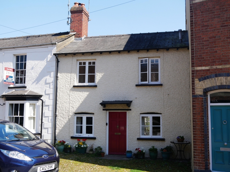
Location: Situated at right end of group of roughcast houses on the E side of Castle Street, just after a large late C19 red brick house.
County: Monmouthshire
Town: Raglan
Community: Raglan (Rhaglan)
Community: Raglan
Built-Up Area: Raglan
Traditional County: Monmouthshire
Tagged with: Building
House in a terraced row of earlier to mid C19 houses on the approach street to the castle. The house may have 2 phases of building, the ground floor windows being smaller than those above. Also known as Bwthyn Ger-y-nant.
House, roughcast, whitewashed with slate roof and red brick left end stack, shared with No 8. Two storeys, double-fronted with 4 casement windows and central door with wooden lintel and flat canopy on brackets. Ground floor casement pairs with cambered heads, first floor longer casement pairs with flat heads and late C19 or early C20 glazing-bar pattern.
Interior not available for inspection at time of resurvey (December 1999)
Listed as a small early to mid C19 terraced house, of group value with nos. 8 and 9 Castle Street, in a terraced row.
External links are from the relevant listing authority and, where applicable, Wikidata. Wikidata IDs may be related buildings as well as this specific building. If you want to add or update a link, you will need to do so by editing the Wikidata entry.


Other nearby listed buildings
