History in Structure

Well-house on E side of lane, opposite village hall

A Grade II Listed Building in Llangattock-Vibon-Avel, Monmouthshire

More Photos »
Approximate Location Map
Large Map »

Coordinates

Latitude: 51.8742 / 51°52'26"N

Longitude: -2.8632 / 2°51'47"W

OS Eastings: 340669

OS Northings: 219861

OS Grid: SO406198

Mapcode National: GBR FD.S0DP

Mapcode Global: VH793.B563

Plus Code: 9C3VV4FP+MP

Entry Name: Well-house on E side of lane, opposite village hall

Listing Date: 19 March 2001

Last Amended: 19 March 2001

Grade: II

Source: Cadw

Source ID: 25021

Building Class: Water Supply and Drainage

ID on this website: 300025021

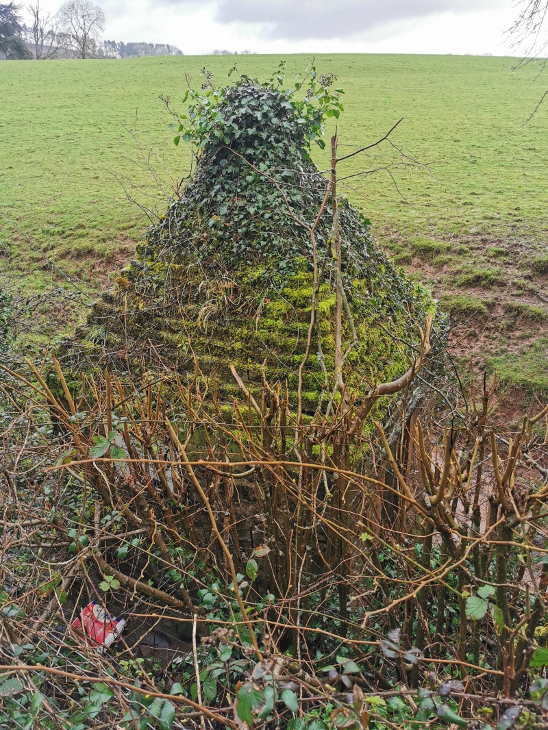
Location: Behind the hedge on the E side of a lane running N from Cross Ash Post Office and approximately 130m N of it, opposite the village hall.

County: Monmouthshire

Town: Monmouth

Community: Llangattock-Vibon-Avel (Llangatwg Feibion Afel)

Community: Skenfrith

Locality: Cross Ash

Traditional County: Monmouthshire

Tagged with: Well

Find accommodation in
Llanfaenor

History

Small well-house, probably C18 or early C19.

Exterior

Built of coursed sandstone rubble and some old brick. Approximately 2m square and 2m high to the top of the walls and a steep pyramidal roof of stepped courses. The S side has a doorway with a board door.

Interior

Not inspected.

Reasons for Listing

Listed as a simple example of a distinctive and unusual building type; one of a group of similar buildings in this locality, with Well house to N of Graig House (q.v.) and Stone Well-house opposite New Inn Farm (q.v.).

External Links

External links are from the relevant listing authority and, where applicable, Wikidata. Wikidata IDs may be related buildings as well as this specific building. If you want to add or update a link, you will need to do so by editing the Wikidata entry.

Recommended Books

Other nearby listed buildings

  • II Former coach-house and screen wall to W of Graig House
    The screen wall is attached to the W gable of Graig House (q.v.) and runs approx. 60m WSW, where it is attached to the E side of the former coach-house.
  • II Graig House (aka Great Graig) including terrace to S and E
    Standing in its own grounds on the E. side of a lane approx. half a kilometre north of Cross Ash Post Office.
  • II Cross Ash Farmhouse
    Standing at the junction of the B4521 with a lane leading to Wayne Green, approximately 250m S of Cross Ash Post Office.
  • II Well-house to N of Graig House
    Situated on the north side of the lane passing the rear of Graig House, and approximately opposite that house.
  • II Stone Wellhouse opposite New Inn Farm
    Approximately 1km NW of Cross Ash post office, on the N side of a lane leading to Grosmont.
  • II Lantellen Farmhouse
    Approximately 1.4km ENE of Cross Ash post office, in an isolated position at the end of a lane off the N side of the B4521
  • II Nant-yr-yrch Farmhouse
    Approximately 2km NE of Cross Ash Post Office, embowered in a hollow where the Black Brook crosses a lane which links the B4521 with the B4347
  • II The Pant
    Approximately 4km N of Llantilio Crossenny, built on sloping ground on S side of minor road, some 300m E of fork at Hill House on B 4521.

BritishListedBuildings.co.uk is an independent online resource and is not associated with any government department. All government data published here is used under licence. Please do not contact BritishListedBuildings.co.uk for any queries related to any individual listed building, planning permission related to listed buildings or the listing process itself.

British Listed Buildings is a Good Stuff website.