Approximate Location Map
Large Map »
Latitude: 51.8261 / 51°49'33"N
Longitude: -2.7483 / 2°44'53"W
OS Eastings: 348524
OS Northings: 214426
OS Grid: SO485144
Mapcode National: GBR FJ.W4X7
Mapcode Global: VH86T.9CYG
Plus Code: 9C3VR7G2+CM
Entry Name: Monmouth Lodge
Listing Date: 19 March 2001
Last Amended: 19 March 2001
Grade: II
Source: Cadw
Source ID: 25040
Building Class: Domestic
ID on this website: 300025040
Location: Built in the acute angle formed by the junction of the drive with the B4233, approximately 200m SE of the centre of Rockfield village.
County: Monmouthshire
Town: Monmouth
Community: Llangattock-Vibon-Avel (Llangatwg Feibion Afel)
Community: Whitecastle
Locality: Rockfield
Traditional County: Monmouthshire
Tagged with: Gatehouse Scottish Baronial architecture
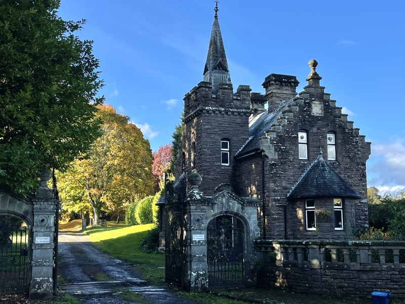
Designed by Aston Webb, and dated 1896. Scottish baronial style said to have been at the wish of Georgiana Maclean who had married John Allen Rolls of The Hendre.
A former gate lodge to The Hendre. Walls of random rubble, roofs of red tiles with gable parapets and fleur-de-lis ridge tiles. Irregular plan with a short main range parallel to the road (but not facing it), a rear crosswing and a porch-tower in the S angle thus formed. One-and-a-half and 2 storeys in a theatrically-eclectic style. Striking composition when seen by visitors arriving from the Monmouth direction as their carriages forked off the public road. This consists of the E gable-end of the main range with the porch-tower set back on its S side. The gable wall has an unusual single-storey semi-circular "turret" at ground floor level, with a steep semi-conical tiled roof and a chamfered 1-light window in each of its 3 cardinal sides; a pair of narrow chamfered 1-light attic windows flanking the apex; and a steep crow-stepped parapet with a ball finial on the apex. The set-back porch-tower to the left, which is 2-storeyed, has steps up to a round-headed arch containing a square-headed doorway with the date 1896 in the tympanum, a small chamfered 1-light window at 1st floor, a corbelled and embattlemented parapet and a tall pyramidal flèche with triangular lucarnes and a finial. The N and S gables of the rear wing match the front gable. The front and rear ranges each have a large chimney with a corbelled cap.
(The design was almost exactly repeated for North Lodge in Hendre (q.v.)
The item forms a good group with its associated gateway (q.v.).
Included as a picturesquely composed and detailed lodge, part of a fine set of buildings on the Hendre estate.
External links are from the relevant listing authority and, where applicable, Wikidata. Wikidata IDs may be related buildings as well as this specific building. If you want to add or update a link, you will need to do so by editing the Wikidata entry.


Other nearby listed buildings
