Approximate Location Map
Large Map »
Latitude: 51.7175 / 51°43'3"N
Longitude: -3.8472 / 3°50'50"W
OS Eastings: 272486
OS Northings: 203704
OS Grid: SN724037
Mapcode National: GBR H1.2T6F
Mapcode Global: VH4JZ.83G5
Plus Code: 9C3RP593+24
Entry Name: Pont ar Dawe (partly in Pontardawe community)
Listing Date: 26 October 1979
Last Amended: 16 December 2003
Grade: II
Source: Cadw
Source ID: 82294
Building Class: Transport
ID on this website: 300082294
Location: Spanning the Afon Tawe between the communities of Cilybebyll and Pontardawe.
County: Neath Port Talbot
Town: Swansea
Community: Cilybebyll
Community: Cilybebyll
Locality: Pontardawe
Built-Up Area: Pontardawe
Traditional County: Glamorgan
Tagged with: Bridge
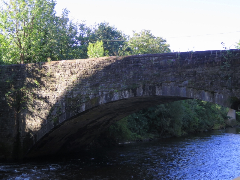
Road bridge over the Tawe, now disused as a vehicle crossing, uncertain date possibly c1765 or possibly 1784, by Rev. William Edwards of Pontypridd. Originally some 3m wide, widened to 8.2m in 1893 with new parapets. G. Breese says that this is not the bridge built by Edwards c1765 as that had spandrel holes like Edwards famous bridge at Pontypridd, but all other sources say that this is the Edwards bridge. The bridge is mentioned by B. Malkin in 1804 and by T.Rees in 1819 when the abutments are said to have been solid.
Road bridge, rubble stone, broad single arch of 26m span with thin stone voussoirs and thin stones to original spandrels and crown on S side. Abutments each side have battered faces. Later C19 doubling in width in rock-faced squared sandstone with cut stone voussoirs. Parapets on both sides also later C19 with rock-faced chamfered coping stones with tooled edges. Raised piers at ends of parapets with ridge-back copings.
Included as an important C18 road bridge by the leading Welsh bridge builder.
External links are from the relevant listing authority and, where applicable, Wikidata. Wikidata IDs may be related buildings as well as this specific building. If you want to add or update a link, you will need to do so by editing the Wikidata entry.


Other nearby listed buildings
