Approximate Location Map
Large Map »
Latitude: 51.632 / 51°37'55"N
Longitude: -3.8225 / 3°49'20"W
OS Eastings: 273959
OS Northings: 194148
OS Grid: SS739941
Mapcode National: GBR H2.8F6M
Mapcode Global: VH4KC.P7KR
Plus Code: 9C3RJ5JH+Q2
Entry Name: Former Steam Power House at Briton Ferry Docks
Listing Date: 14 September 2005
Last Amended: 14 September 2005
Grade: II
Source: Cadw
Source ID: 84394
Building Class: Industrial
ID on this website: 300084394
Location: Behind the buildings along Dock Street and lying to N of the filled-in portion of the dock. The Power House occupies part of a triangular site between the main railway line and the railway sidings to
County: Neath Port Talbot
Community: Briton Ferry (Llansawel)
Community: Briton Ferry
Locality: Briton Ferry Docks
Built-Up Area: Neath
Traditional County: Glamorgan
Tagged with: Architectural structure
The Briton Ferry Dock Act was passed in 1851, a company was formed and work started in 1853; the dock opened in 1861. Its engineer was Isambard Kingdom Brunel who died in 1859 before the project which was completed by the contractor William Ritson; the machinery was installed by Sir William Armstrong. It comprised an inner floating dock and an outer tidal basin, between which was a hydraulically powered lock gate. The hydraulic power for the accumulator tower was generated from this engine house some distance away. The dock closed in 1959, subsequent to which the inner floating dock has silted up, with the high-level A48 and M4 built partly over it, and its entrance infilled.
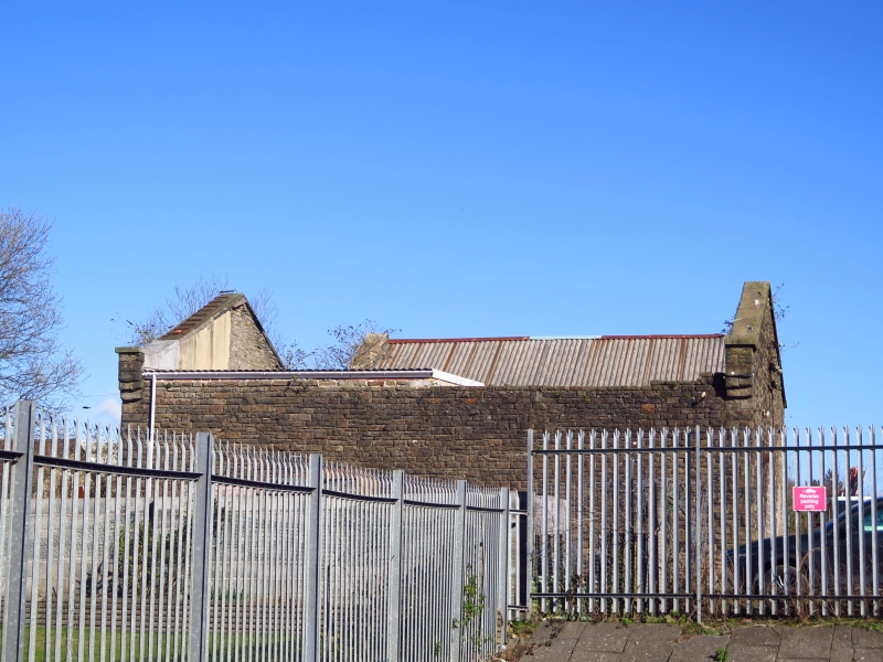
Single-storey, twin-gabled power-house with N parallel range stepped back and with a lower flat roofed extension attached on N side. Rock-faced, coursed masonry with dressed quoins and voussoirs to (blocked) openings; flat ashlar cappings to gable parapets which are stepped forward over doors to N range. Snecked masonry and dressed plinth course to N extension. Roof coverings removed, though pitched corrugated iron covers the N parallel range. Triple arched openings (blocked) to both ranges facing the main railway lines; impost blocks to voussoir surrounds on N range with larger openings to W side covered by sliding metal doors.
Listed for the special industrial archaeological interest of its association with Brunel's innovative lock gate with bouyancy chambers and the listed Hydro-Accumulator Tower at Briton ferry Docks.
External links are from the relevant listing authority and, where applicable, Wikidata. Wikidata IDs may be related buildings as well as this specific building. If you want to add or update a link, you will need to do so by editing the Wikidata entry.


Other nearby listed buildings
