Approximate Location Map
Large Map »
Latitude: 51.8122 / 51°48'44"N
Longitude: -2.7127 / 2°42'45"W
OS Eastings: 350962
OS Northings: 212863
OS Grid: SO509128
Mapcode National: GBR FL.X1Q0
Mapcode Global: VH86T.XQR3
Plus Code: 9C3VR76P+VW
Entry Name: 32, St. Mary's Street
Listing Date: 15 August 1974
Last Amended: 10 August 2005
Grade: II
Source: Cadw
Source ID: 85105
ID on this website: 300085105
Location: Part of a group in the important residential street leading south-east from the parish church.
County: Monmouthshire
Town: Monmouth
Community: Monmouth (Trefynwy)
Community: Monmouth
Built-Up Area: Monmouth
Traditional County: Monmouthshire
Tagged with: Building
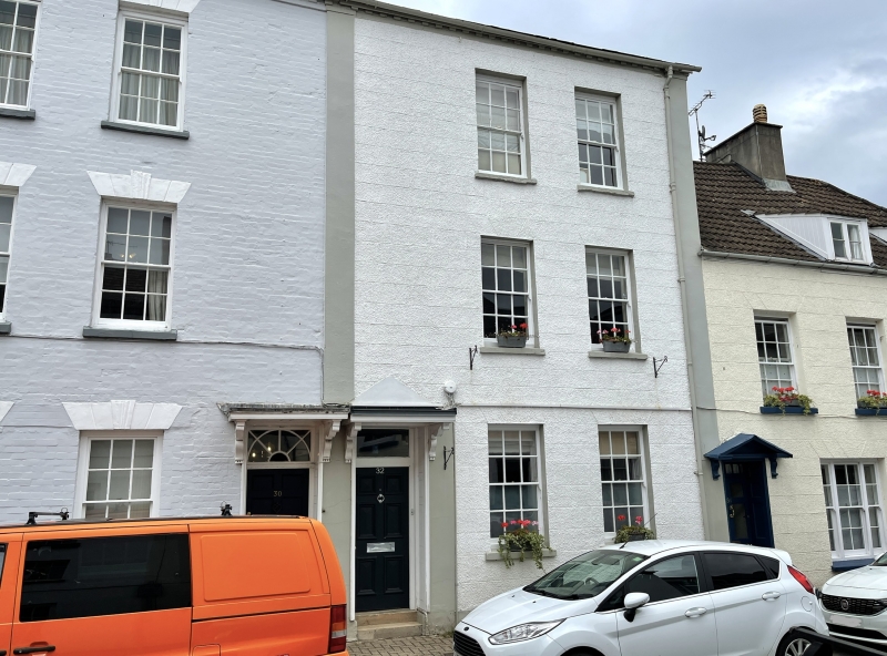
Late C18 or early C19, probably very near to 1800 and possibly built as two pairs since Nos. 26 and 28 have their doorways on the outside and Nos. 30 and 32 on the inside.
Built of brick, but Nos. 26 and 32 are pebble-dashed and Nos. 28 and 30 are rendered and painted, Welsh slate roof. Three storey double depth terrace. Six over 6 pane sash windows, with keystones and voussoirs except for No. 28. No. 30 had a ground floor shopfront at listing in 1974, but this is now replaced by two windows. No 32 roughcast with a modern porch. Six-panel doors, Nos. 26, 28 and 30 have fan transoms over doors, and flat hoods supported on brackets, No. 32 has a modern canted hood. M-roof running parallel with the street, the front slope appears to have been altered, heightening the front wall, stack in between Nos. 26 and 28 and on outside walls of Nos. 30 and 32.
Rear elevation shows sash windows with 6 over 6 panes to No. 26, a large late C20 dormer to No. 28, gabled late C20 rear wings to Nos. 30 and 32.
Interior not seen at resurvey (August 2004).
Included for its special architectural interest as a late C18 or early C19 terrace of four houses of definite character in the Monmouth town centre.
External links are from the relevant listing authority and, where applicable, Wikidata. Wikidata IDs may be related buildings as well as this specific building. If you want to add or update a link, you will need to do so by editing the Wikidata entry.


Other nearby listed buildings
