History in Structure

8, St. Mary's Street

A Grade II Listed Building in Monmouth, Monmouthshire

More Photos »
Approximate Location Map
Large Map »

Coordinates

Latitude: 51.8126 / 51°48'45"N

Longitude: -2.7137 / 2°42'49"W

OS Eastings: 350894

OS Northings: 212898

OS Grid: SO508128

Mapcode National: GBR FL.WTR6

Mapcode Global: VH86T.XP7V

Plus Code: 9C3VR77P+2G

Entry Name: 8, St. Mary's Street

Listing Date: 10 August 2005

Last Amended: 10 August 2005

Grade: II

Source: Cadw

Source ID: 85169

Building Class: Domestic

ID on this website: 300085169

Location: Part of a group in the important residential street leading south-east from the parish church.

County: Monmouthshire

Town: Monmouth

Community: Monmouth (Trefynwy)

Community: Monmouth

Built-Up Area: Monmouth

Traditional County: Monmouthshire

Tagged with: Building

Find accommodation in
Monmouth

History

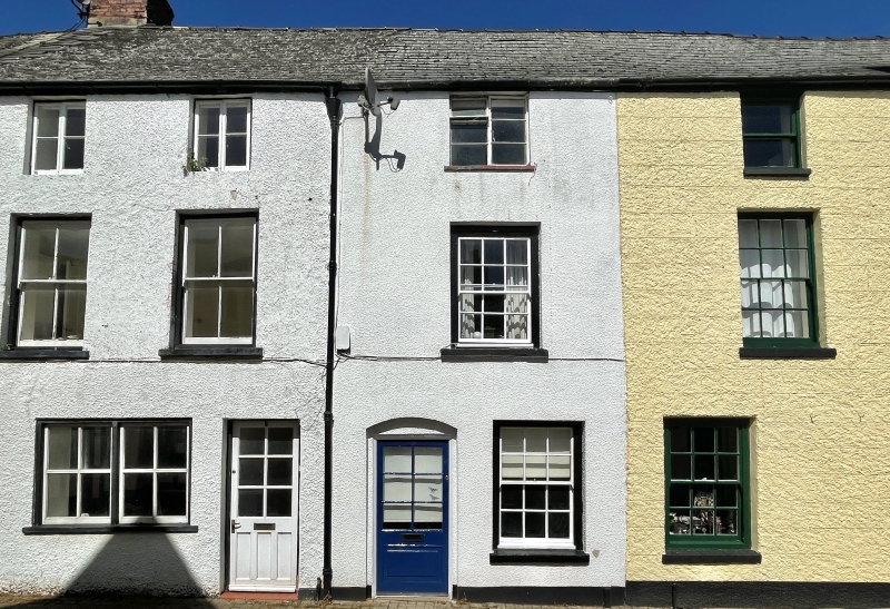
Early C19, with some alteration to detail since. It may have been built together with No. 6 adjoining (qv) but has differences of detail.

Exterior

Rendered and painted front, Welsh slate roof. Double depth plan. Three storeys, three windows to whole 2 : 1. The ground floor has a paired sash to left with 2 over 2 pane sashes, two part glazed doors in the centre and 6 over 6 pane sash to right. First floor has 2 over 2 pane sashes to left and 6 over 6 to right. Upper floor has two 2 2 pane casements to left and C20 steel casement to right. Modestly pitched roof with brick gable stacks. Rear elevation not seen.

Interior

Interior not seen at resurvey.

Reasons for Listing

Included for its special architectural interest as an early C19 house of definite character in the Monmouth town centre.

External Links

External links are from the relevant listing authority and, where applicable, Wikidata. Wikidata IDs may be related buildings as well as this specific building. If you want to add or update a link, you will need to do so by editing the Wikidata entry.

Recommended Books

Other nearby listed buildings

  • II 6, St. Mary's Street
    Part of a group in the important residential street leading south-east from the parish church.
  • II The Malt House Coffee Shop
    About 50m from junction with Whitecross Street. Part of a group in the important residential street leading south-east from the parish church.
  • II 9, St. Mary's Street
    At the bend in the road part way along this varied residential street leading south-east from the parish church.
  • II 5, Whitecross Street
    On the street continuing Church Street east out of the town centre.
  • II 3, Whitecross Street
    On the street continuing Church Street east out of the town centre.
  • II Brecon House
    On the street continuing Church Street east out of the town centre.
  • II NO.19 St.mary's Street, Gwent
    Part of a group in the important residential street leading south-east from the parish church.
  • II The Griffin PH
    On the street continuing Church Street east out of the town centre. At the foot of the Public House walls is a rare surviving example of a hollowed sandstone gutter which goes round the street corner.

BritishListedBuildings.co.uk is an independent online resource and is not associated with any government department. All government data published here is used under licence. Please do not contact BritishListedBuildings.co.uk for any queries related to any individual listed building, planning permission related to listed buildings or the listing process itself.

British Listed Buildings is a Good Stuff website.